
Fai una donazione
Preparati per la tua prossima avventura:
In qualità di associato Amazon, questo sito riceve una commissione sugli acquisti idonei senza alcun costo aggiuntivo per te.
Mappa topografica Kullu
Clicca sulla mappa per visualizzare l'altitudine.
Fai una donazione
Preparati per la tua prossima avventura:
In qualità di associato Amazon, questo sito riceve una commissione sugli acquisti idonei senza alcun costo aggiuntivo per te.
Kullu
Kullu town has an average elevation of 1,278 m (4,193 ft). It lies on the bank of Beas River. A major tributary, Sarvari, (derived from "Shiv-Baardi") leads to the less explored and steeper Lug-valley on the west. On the east of Kullu lies a broad mountainous ridge having the village-temples of Bijli Mahadev, Anant Nag and Peej. Beyond the ridge lies Manikaran valley, along the Parvati river which joins Beas at in Bhuntar. On the south of Kullu lie the towns of Bhuntar and Aut, leading to Anni, Banjar, the Sainj Valley) and Mandi (in Mandi district). Historically Kullu was accessible from Shimla via the Seraj valley, or through passes on the west leading to Jogindernagar and onto the district of Kangra. 40 km. north lies the rather famous town of Manali. A few hours of a very winding car ride on the main highway leads to Rohtang Pass and the source of the Beas river, at 13,500 ft, 4110 m. The same road continues on to the Lahaul and Spiti Valley(now also accessible by Atal tunnel). One can see an enormous change in the climate as one climbs up the windward side of the ranges to proceed to the leeward and much drier plateaus to the north of Manali.
Fai una donazione
Preparati per la tua prossima avventura:
In qualità di associato Amazon, questo sito riceve una commissione sugli acquisti idonei senza alcun costo aggiuntivo per te.
A proposito di questa mappa
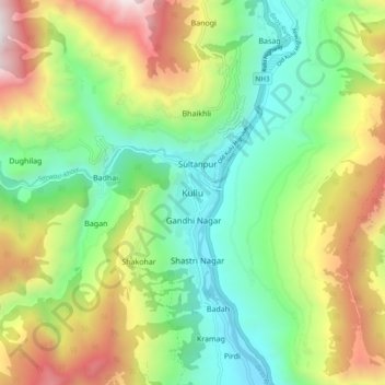
Nome: Mappa topografica Kullu, altitudine, rilievo.
Luogo: Kullu, Himachal Pradesh, 175100, India (31.91790 77.06892 31.99790 77.14892)
Altitudine media: 1.808 m
Altitudine minima: 1.130 m
Altitudine massima: 2.972 m
Fai una donazione
Preparati per la tua prossima avventura:
In qualità di associato Amazon, questo sito riceve una commissione sugli acquisti idonei senza alcun costo aggiuntivo per te.
Altre mappe topografiche
Clicca su una mappa per visualizzarne la topografia, l'altitudine e il rilievo.