
Fai una donazione
Preparati per la tua prossima avventura:
In qualità di associato Amazon, questo sito riceve una commissione sugli acquisti idonei senza alcun costo aggiuntivo per te.
Mappa topografica Indian Lake
Clicca sulla mappa per visualizzare l'altitudine.
Fai una donazione
Preparati per la tua prossima avventura:
In qualità di associato Amazon, questo sito riceve una commissione sugli acquisti idonei senza alcun costo aggiuntivo per te.
Indian Lake
Indian Lake has the fourth-highest elevation of towns in Pennsylvania, at 2281 feet. This is the Lake water level, homes at Indian Lake range from 2300 to 2550 feet in base elevation.
Fai una donazione
Preparati per la tua prossima avventura:
In qualità di associato Amazon, questo sito riceve una commissione sugli acquisti idonei senza alcun costo aggiuntivo per te.
A proposito di questa mappa
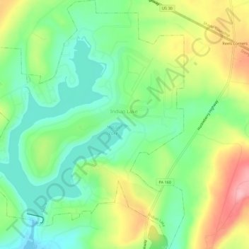
Nome: Mappa topografica Indian Lake, altitudine, rilievo.
Luogo: Indian Lake, Somerset County, Pennsylvania, United States (40.02331 -78.88721 40.06545 -78.83897)
Altitudine media: 732 m
Altitudine minima: 679 m
Altitudine massima: 817 m
Fai una donazione
Preparati per la tua prossima avventura:
In qualità di associato Amazon, questo sito riceve una commissione sugli acquisti idonei senza alcun costo aggiuntivo per te.