
Mappa topografica Beith
Clicca sulla mappa per visualizzare l'altitudine.
A proposito di questa mappa
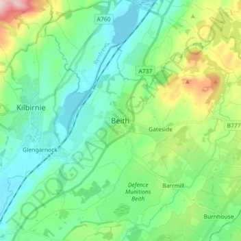
Nome: Mappa topografica Beith, altitudine, rilievo.
Luogo: Beith, North Ayrshire, Scotland, KA15 1BS, United Kingdom (55.71071 -4.67278 55.79071 -4.59278)
Altitudine media: 92 m
Altitudine minima: 23 m
Altitudine massima: 297 m
Altre mappe topografiche
Clicca su una mappa per visualizzarne la topografia, l'altitudine e il rilievo.
Isle of Arran
United Kingdom > Scotland > North Ayrshire
The island has three endemic species of tree, the Arran whitebeams. These trees are the Scottish or Arran whitebeam (Sorbus arranensis), the bastard mountain ash or cut-leaved whitebeam (Sorbus pseudofennica) and the Catacol whitebeam (Sorbus pseudomeinichii). If rarity is measured by numbers alone they are…
Altitudine media: 98 m