
Fai una donazione
Preparati per la tua prossima avventura:
In qualità di associato Amazon, questo sito riceve una commissione sugli acquisti idonei senza alcun costo aggiuntivo per te.
Mappa topografica Maseru
Clicca sulla mappa per visualizzare l'altitudine.
Fai una donazione
Preparati per la tua prossima avventura:
In qualità di associato Amazon, questo sito riceve una commissione sugli acquisti idonei senza alcun costo aggiuntivo per te.
Maseru
Maseru is located in northwest Lesotho by the South African border, denoted by the Mohokare River. Mohokare River is also known as Caledon River. The two countries are connected by a border post at the Maseru Bridge, which crosses the river. On the South African side, Ladybrand is the town closest to Maseru. The city lies in a shallow valley at the foot of the Hlabeng-Sa-Likhama, foothills of the Maloti Mountains.[1] The elevation of the city is listed as 1,600 metres (5,200 ft) above sea level.[11] The city has an area of around 138 square kilometres (53 sq mi).[5]
Fai una donazione
Preparati per la tua prossima avventura:
In qualità di associato Amazon, questo sito riceve una commissione sugli acquisti idonei senza alcun costo aggiuntivo per te.
A proposito di questa mappa
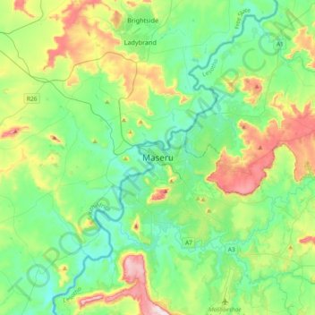
Nome: Mappa topografica Maseru, altitudine, rilievo.
Luogo: Maseru, Maseru District, 100, Lesotho (-29.47005 27.31822 -29.15005 27.63822)
Altitudine media: 1.606 m
Altitudine minima: 1.460 m
Altitudine massima: 1.991 m
Fai una donazione
Preparati per la tua prossima avventura:
In qualità di associato Amazon, questo sito riceve una commissione sugli acquisti idonei senza alcun costo aggiuntivo per te.