
Fai una donazione
Preparati per la tua prossima avventura:
In qualità di associato Amazon, questo sito riceve una commissione sugli acquisti idonei senza alcun costo aggiuntivo per te.
Mappa topografica Scopello
Clicca sulla mappa per visualizzare l'altitudine.
Fai una donazione
Preparati per la tua prossima avventura:
In qualità di associato Amazon, questo sito riceve una commissione sugli acquisti idonei senza alcun costo aggiuntivo per te.
Scopello
Scopello è un piccolo paese del Piemonte situato nella parte nord-occidentale della provincia di Vercelli, nella Valsesia settentrionale. Il territorio comunale di Scopello presenta delle variazioni di altitudine molto accentuate: il fondovalle è posto a circa 660 metri di quota ed è qui che si concentra l'abitato, lungo il fiume Sesia. Mentre i punti più alti sono rappresentati dai centri abitati di Frasso e Alpe di Mera nonché dalle molteplici cime che corniciano la valle. Sulla sinistra idrografica della vallata si trova la Comba di Frasso, un selvaggio vallone che confina con la Val Sermenza e culmina con la Cima delle Balme (1.930 m) e il Monte Ventolaro (1.836 m). Sulla destra della Sesia il comune si suddivide in due lembi: il primo comprende la frazione Chioso e si spinge verso sud-est arrivando a toccare i 1.925 metri in corrispondenza del Badile. La porzione sud-occidentale del territorio, che culmina invece con la Cima dell'Ometto (1.911) e il Monte Camparient (1.741 m), comprende l'Alpe di Mera e la Bocchetta della Boscarola. A sud dello spartiacque Sesia-Sessera un lembo del comune scende in Valsessera fino al Torrente Dolca, il quale segna il confine con una frazione montana del comune biellese di Valle San Nicolao.
Fai una donazione
Preparati per la tua prossima avventura:
In qualità di associato Amazon, questo sito riceve una commissione sugli acquisti idonei senza alcun costo aggiuntivo per te.
A proposito di questa mappa
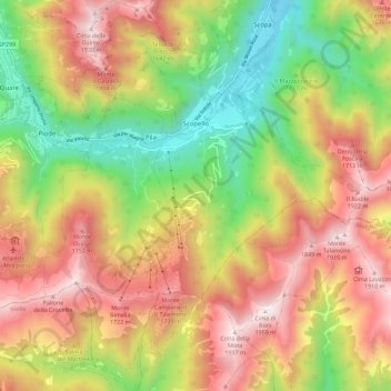
Nome: Mappa topografica Scopello, altitudine, rilievo.
Luogo: Scopello, Vercelli, Piemonte, 13028, Italia (45.71875 8.05898 45.79749 8.14081)
Altitudine media: 1.256 m
Altitudine minima: 595 m
Altitudine massima: 1.935 m
Fai una donazione
Preparati per la tua prossima avventura:
In qualità di associato Amazon, questo sito riceve una commissione sugli acquisti idonei senza alcun costo aggiuntivo per te.
Altre mappe topografiche
Clicca su una mappa per visualizzarne la topografia, l'altitudine e il rilievo.
Fai una donazione
Preparati per la tua prossima avventura:
In qualità di associato Amazon, questo sito riceve una commissione sugli acquisti idonei senza alcun costo aggiuntivo per te.
Fai una donazione
Preparati per la tua prossima avventura:
In qualità di associato Amazon, questo sito riceve una commissione sugli acquisti idonei senza alcun costo aggiuntivo per te.
Fai una donazione
Preparati per la tua prossima avventura:
In qualità di associato Amazon, questo sito riceve una commissione sugli acquisti idonei senza alcun costo aggiuntivo per te.
Fai una donazione
Preparati per la tua prossima avventura:
In qualità di associato Amazon, questo sito riceve una commissione sugli acquisti idonei senza alcun costo aggiuntivo per te.
Fai una donazione
Preparati per la tua prossima avventura:
In qualità di associato Amazon, questo sito riceve una commissione sugli acquisti idonei senza alcun costo aggiuntivo per te.
Monte Tagliaferro
Italia > Piemonte > Vercelli > Alagna Valsesia
Alle sue pendici si trovano, a nord, il Colle Mud (2 324 m), a sud, la Bocchetta della Moanda (2 422 m) e il Passo del Gatto (2 714 m). I primi due valichi erano e sono percorsi da due sentieri che uniscono Alagna (frazione Pedemonte) con la Val Sermenza, un tempo importanti vie di comunicazione per le genti…
Altitudine media: 2.268 m
Fai una donazione
Preparati per la tua prossima avventura:
In qualità di associato Amazon, questo sito riceve una commissione sugli acquisti idonei senza alcun costo aggiuntivo per te.
Alpe di Mera
Italia > Piemonte > Vercelli > Scopello
L'Alpe di Mera è una località valsesiana turistica montana situata nel comune di Scopello, in Piemonte, sulle Alpi Pennine, ad un'altitudine compresa tra i 1500 e i 1700 m sul livello del mare.
Altitudine media: 1.348 m
Fai una donazione
Preparati per la tua prossima avventura:
In qualità di associato Amazon, questo sito riceve una commissione sugli acquisti idonei senza alcun costo aggiuntivo per te.
Camasco
Italia > Piemonte > Vercelli > Varallo
Piccola frazione del comune di Varallo, rispetto al quale dista circa 8 km, situata a un'altitudine di circa 760 metri di quota, sulle pendici della Cima del Camossaro e dell'Alpe Ranghetto, che sorge sulle montagne dello spartiacque che divide l'alta Valsesia dal Lago d'Orta.
Altitudine media: 969 m
Fai una donazione
Preparati per la tua prossima avventura:
In qualità di associato Amazon, questo sito riceve una commissione sugli acquisti idonei senza alcun costo aggiuntivo per te.
Fai una donazione
Preparati per la tua prossima avventura:
In qualità di associato Amazon, questo sito riceve una commissione sugli acquisti idonei senza alcun costo aggiuntivo per te.
Monte Tagliaferro
Italia > Piemonte > Vercelli > Alagna Valsesia
Alle sue pendici si trovano, a nord, il Colle Mud (2 324 m), a sud, la Bocchetta della Moanda (2 422 m) e il Passo del Gatto (2 714 m). I primi due valichi erano e sono percorsi da due sentieri che uniscono Alagna (frazione Pedemonte) con la Val Sermenza, un tempo importanti vie di comunicazione per le genti…
Altitudine media: 2.268 m
Fai una donazione
Preparati per la tua prossima avventura:
In qualità di associato Amazon, questo sito riceve una commissione sugli acquisti idonei senza alcun costo aggiuntivo per te.
Monte Capio
Italia > Piemonte > Vercelli > Cravagliana
La montagna si trova sullo spartiacque Valle Strona/Val Mastallone, alla convergenza della Valbella e del vallone del torrente Rondo (versante valsesiano) con il vallone del Rio dei Dannati (un affluente dello Strona di Omegna). Lungo lo spartiacque principale in direzione sud-est il Passo dei Rossi (2.056 m)…
Altitudine media: 1.775 m
Fai una donazione
Preparati per la tua prossima avventura:
In qualità di associato Amazon, questo sito riceve una commissione sugli acquisti idonei senza alcun costo aggiuntivo per te.
Fai una donazione
Preparati per la tua prossima avventura:
In qualità di associato Amazon, questo sito riceve una commissione sugli acquisti idonei senza alcun costo aggiuntivo per te.
Fai una donazione
Preparati per la tua prossima avventura:
In qualità di associato Amazon, questo sito riceve una commissione sugli acquisti idonei senza alcun costo aggiuntivo per te.
Fai una donazione
Preparati per la tua prossima avventura:
In qualità di associato Amazon, questo sito riceve una commissione sugli acquisti idonei senza alcun costo aggiuntivo per te.