
Mappa topografica Alderley Edge
Mappa interattiva
Clicca sulla mappa per visualizzare l'altitudine.
A proposito di questa mappa
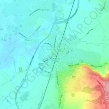
Nome: Mappa topografica Alderley Edge, altitudine, rilievo.
Altitudine media: 91 m
Altitudine minima: 63 m
Altitudine massima: 194 m
Alderley Edge is 6 miles (10 km) northwest of Macclesfield and 12 miles (19 km) south of Manchester, at the base of a steep and thickly wooded sandstone escarpment, Alderley Edge, which is the area's chief topographical feature and overlooks the Cheshire Plain.