
Mappa topografica Yellowstone Lake
Mappa interattiva
Clicca sulla mappa per visualizzare l'altitudine.
A proposito di questa mappa
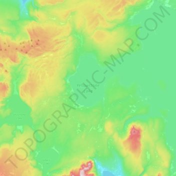
Nome: Mappa topografica Yellowstone Lake, altitudine, rilievo.
Luogo: Yellowstone Lake, Teton County, Wyoming, United States (44.27663 -110.58115 44.56399 -110.20122)
Altitudine media: 2.453 m
Altitudine minima: 2.270 m
Altitudine massima: 2.926 m
The lake has been known by various names as depicted on early maps and in journals. Both fur trader David Thompson and explorer William Clark referred to the lake as Yellow Stone. Osborne Russell referred to the lake as Yellow Stone Lake in his 1834 journal. On some William Clark maps, the lake has the name Eustis Lake and the name Sublette's Lake was also used to name the lake in the early 19th century. The name Yellowstone Lake appears formally first in the 1839 maps of the Oregon Territory by U.S. Army topographical engineer, Captain Washington Hood and has remained so since that time.
Altre mappe topografiche
Clicca su una mappa per visualizzarne la topografia, l'altitudine e il rilievo.
Grand Teton National Park
United States > Wyoming > Teton County
Grand Teton National Park, Teton County, Wyoming, United States
Altitudine media: 2.409 m
Teton Village
United States > Wyoming > Teton County
Teton Village, Teton County, Wyoming, 83025, United States
Altitudine media: 2.144 m
Rocky Mountains
United States > Wyoming > Teton County
Rocky Mountains, Teton County, Wyoming, United States
Altitudine media: 2.292 m
Pacific Creek
United States > Wyoming > Teton County
Pacific Creek, Teton County, Wyoming, United States
Altitudine media: 2.434 m
Isa Lake
United States > Wyoming > Teton County
Isa Lake, Teton County, Wyoming, United States
Altitudine media: 2.503 m
Jackson
United States > Wyoming > Teton County
Jackson, Teton County, Wyoming, 83002, United States
Altitudine media: 2.043 m
Disappointment Peak
United States > Wyoming > Teton County
Disappointment Peak, Teton County, Wyoming, United States
Altitudine media: 3.255 m
Moran
United States > Wyoming > Teton County > Moran
Moran, Teton County, Wyoming, United States
Altitudine media: 2.088 m
Upper Geyser Basin
United States > Wyoming > Teton County > Upper Geyser Basin
Upper Geyser Basin, Teton County, Wyoming, United States
Altitudine media: 2.295 m
Buck Mountain
United States > Wyoming > Teton County
Buck Mountain, Teton County, Wyoming, United States
Altitudine media: 3.128 m
Grand Teton
United States > Wyoming > Teton County
Grand Teton, Teton County, Wyoming, United States
Altitudine media: 3.330 m