
Mappa topografica Cauayan
Mappa interattiva
Clicca sulla mappa per visualizzare l'altitudine.
Cauayan
The municipality of Cauayan has a rugged topography. Mt. Malipantao, considered the highest peak in the province, separates the municipality from the town of Candoni and the city of Sipalay. Portion of the ranges are the remaining thick forest that needs protection where the watershed is located. The remaining portions of the municipality are slightly rolling to moderate large areas of flat lands center on the different barrios, which is much suited to agriculture.
A proposito di questa mappa
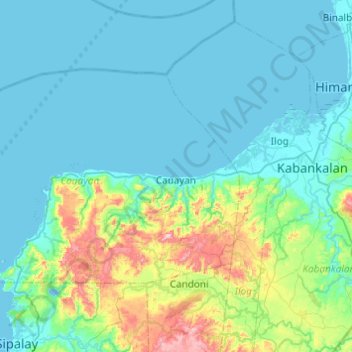
Nome: Mappa topografica Cauayan, altitudine, rilievo.
Altitudine media: 91 m
Altitudine minima: -3 m
Altitudine massima: 601 m
Altre mappe topografiche
Clicca su una mappa per visualizzarne la topografia, l'altitudine e il rilievo.
Kanlaon
Philippines > Negros Occidental > La Castellana
Kanlaon, also known as Mount Kanlaon and Kanlaon Volcano (Hiligaynon: Bolkang Kanglaon; Cebuano: Bolkang Kanglaon; Filipino: Bulkang Kanlaon), is an active andesitic stratovolcano and the highest mountain on the island of Negros in the Philippines, as well as the highest peak in the Visayas, with an elevation…
Altitudine media: 1.959 m
Himamaylan City Public Plaza
Philippines > Negros Occidental > Himamaylan > Barangay Ⅲ
Altitudine media: 5 m
Mount Kanlaon
Philippines > Negros Occidental > La Castellana
Kanlaon, also known as Mount Kanlaon and Kanlaon Volcano (Hiligaynon: Bolkang Kanglaon; Cebuano: Bolkang Kanglaon; Filipino: Bulkang Kanlaon), is an active stratovolcano and the highest mountain on the island of Negros in the Philippines, as well as the highest point in the Visayas, with an elevation of 2,465…
Altitudine media: 1.920 m
Kanlaon
Philippines > Negros Occidental > La Carlota
Kanlaon, also known as Mount Kanlaon and Kanlaon Volcano (Hiligaynon: Bolkang Kanglaon; Cebuano: Bolkang Kanglaon; Filipino: Bulkang Kanlaon), is an active andesitic stratovolcano and the highest mountain on the island of Negros in the Philippines, as well as the highest peak in the Visayas, with an elevation…
Altitudine media: 1.959 m