
Fai una donazione
Preparati per la tua prossima avventura:
In qualità di associato Amazon, questo sito riceve una commissione sugli acquisti idonei senza alcun costo aggiuntivo per te.
Mappa topografica Rockfall
Clicca sulla mappa per visualizzare l'altitudine.
Fai una donazione
Preparati per la tua prossima avventura:
In qualità di associato Amazon, questo sito riceve una commissione sugli acquisti idonei senza alcun costo aggiuntivo per te.
Rockfall
Middlesex County was created on May 2, 1785, from Hartford and New Haven counties. The county was named for Middlesex, England. Middlesex County is in south-central Connecticut. It is bordered to the south by Long Island Sound and to the southwest by the Hammonasset River, and the Connecticut River bisects the county from north to south. Other waterways are the Menunketesuck River, the Moodus Reservoir, and Bashan Lake. The topography is mostly upland terrain, with river valleys and coastal lowlands. Parklands include Cockaponset State Forest, Meshomasic State Forest Preserve, and Hurd and Devil's Hopyard state parks.
Fai una donazione
Preparati per la tua prossima avventura:
In qualità di associato Amazon, questo sito riceve una commissione sugli acquisti idonei senza alcun costo aggiuntivo per te.
A proposito di questa mappa
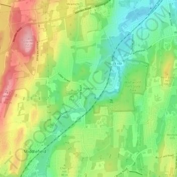
Nome: Mappa topografica Rockfall, altitudine, rilievo.
Altitudine media: 75 m
Altitudine minima: 10 m
Altitudine massima: 161 m
Fai una donazione
Preparati per la tua prossima avventura:
In qualità di associato Amazon, questo sito riceve una commissione sugli acquisti idonei senza alcun costo aggiuntivo per te.