
Fai una donazione
Preparati per la tua prossima avventura:
In qualità di associato Amazon, questo sito riceve una commissione sugli acquisti idonei senza alcun costo aggiuntivo per te.
Mappa topografica Dallas
Clicca sulla mappa per visualizzare l'altitudine.
Fai una donazione
Preparati per la tua prossima avventura:
In qualità di associato Amazon, questo sito riceve una commissione sugli acquisti idonei senza alcun costo aggiuntivo per te.
Dallas
On April 4, 1977, near the site marker for the Battle of New Hope Church, the forced landing of Southern Airways Flight 242 occurred. The passenger jetliner, a McDonnell Douglas DC-9 with 81 passengers and 4 crew members, was flying from Northwest Alabama Regional Airport to Atlanta Municipal Airport. Upon descending in altitude to prepare for landing in Atlanta, the jetliner started to fly through an intense thunderstorm near Rome, Georgia. Because of the extreme amounts of water and hail that were ingested by the jet's engines, both of the Pratt & Whitney JT8D-7A turbojet engines were damaged and underwent flameout. With the engines unable to restart, the flight's crew began gliding in hopes of reaching a nearby airport. Upon finding out that there were no nearby airports to perform a landing, the crew found a straight section of rural road in Dallas, Georgia to try and land. As the plane began to land, it clipped a gas station, convenience store, and other buildings, resulting in the plane to lose control of landing and ultimately crash, resulting in hull loss. Both pilots and 61 passengers were killed by impact forces and fire. Nine people on the ground were also killed.
Fai una donazione
Preparati per la tua prossima avventura:
In qualità di associato Amazon, questo sito riceve una commissione sugli acquisti idonei senza alcun costo aggiuntivo per te.
A proposito di questa mappa
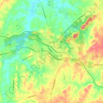
Nome: Mappa topografica Dallas, altitudine, rilievo.
Luogo: Dallas, Paulding County, Georgia, United States (33.88875 -84.89893 33.94127 -84.78327)
Altitudine media: 307 m
Altitudine minima: 252 m
Altitudine massima: 386 m
Fai una donazione
Preparati per la tua prossima avventura:
In qualità di associato Amazon, questo sito riceve una commissione sugli acquisti idonei senza alcun costo aggiuntivo per te.
Altre mappe topografiche
Clicca su una mappa per visualizzarne la topografia, l'altitudine e il rilievo.
Fai una donazione
Preparati per la tua prossima avventura:
In qualità di associato Amazon, questo sito riceve una commissione sugli acquisti idonei senza alcun costo aggiuntivo per te.