
Fai una donazione
Preparati per la tua prossima avventura:
In qualità di associato Amazon, questo sito riceve una commissione sugli acquisti idonei senza alcun costo aggiuntivo per te.
Mappa topografica Kohala
Clicca sulla mappa per visualizzare l'altitudine.
Fai una donazione
Preparati per la tua prossima avventura:
In qualità di associato Amazon, questo sito riceve una commissione sugli acquisti idonei senza alcun costo aggiuntivo per te.
Kohala
In Kohala, the numerous dikes near the summit inhibit groundwater from seeping downslope to the northeast, where it naturally wants to go. Rather, the Kohala dike complex guides it northwest or southeast, down the axis of the rift zones, just like the surface water. On the other hand, the three smaller valleys between the large ones - Honopue, Honokea, and Honokane Iki - as well as the many smaller gulches which are not yet valleys, are deprived of groundwater by the orientation of the rift zone and its dikes. Without the large amount of water that is received by the bigger valleys, these valleys grow far more slowly. Due to its topography as essentially a flat crater floor surrounded by cones and fault scarps, the main caldera is affected relatively little by erosion from water.
Fai una donazione
Preparati per la tua prossima avventura:
In qualità di associato Amazon, questo sito riceve una commissione sugli acquisti idonei senza alcun costo aggiuntivo per te.
A proposito di questa mappa
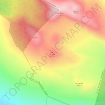
Nome: Mappa topografica Kohala, altitudine, rilievo.
Luogo: Kohala, Hawaiʻi County, Hawaii, United States (20.07494 -155.71874 20.07504 -155.71864)
Altitudine media: 1.489 m
Altitudine minima: 1.233 m
Altitudine massima: 1.665 m
Fai una donazione
Preparati per la tua prossima avventura:
In qualità di associato Amazon, questo sito riceve una commissione sugli acquisti idonei senza alcun costo aggiuntivo per te.
Altre mappe topografiche
Clicca su una mappa per visualizzarne la topografia, l'altitudine e il rilievo.
Fai una donazione
Preparati per la tua prossima avventura:
In qualità di associato Amazon, questo sito riceve una commissione sugli acquisti idonei senza alcun costo aggiuntivo per te.
Kukuihaele CDP
United States > Hawaii > Hawaiʻi County
Kukuihaele is located on the north side of the island of Hawaii at 20°7′10″N 155°34′16″W / 20.11944°N 155.57111°W / 20.11944; -155.57111 (20.119536, -155.571160). It sits at an elevation of 730 feet (220 m) atop cliffs overlooking Waipio Bay. Hawaii Route 240 passes through the southern…
Altitudine media: 173 m
Fai una donazione
Preparati per la tua prossima avventura:
In qualità di associato Amazon, questo sito riceve una commissione sugli acquisti idonei senza alcun costo aggiuntivo per te.
Fai una donazione
Preparati per la tua prossima avventura:
In qualità di associato Amazon, questo sito riceve una commissione sugli acquisti idonei senza alcun costo aggiuntivo per te.
Fai una donazione
Preparati per la tua prossima avventura:
In qualità di associato Amazon, questo sito riceve una commissione sugli acquisti idonei senza alcun costo aggiuntivo per te.
Fai una donazione
Preparati per la tua prossima avventura:
In qualità di associato Amazon, questo sito riceve una commissione sugli acquisti idonei senza alcun costo aggiuntivo per te.