
Fai una donazione
Preparati per la tua prossima avventura:
In qualità di associato Amazon, questo sito riceve una commissione sugli acquisti idonei senza alcun costo aggiuntivo per te.
Mappa topografica Meudon
Clicca sulla mappa per visualizzare l'altitudine.
Fai una donazione
Preparati per la tua prossima avventura:
In qualità di associato Amazon, questo sito riceve una commissione sugli acquisti idonei senza alcun costo aggiuntivo per te.
Meudon
The old castle of Meudon was rebuilt in Renaissance style in the mid-sixteenth century. It was bought by Louis XIV as a residence for his son Louis, the Dauphin under whom Meudon became a center of aristocratic life. After the death of the Dauphin in 1711, the château was neglected, emptied in the Revolutionary sales, and finally burned in 1871 at the close of the Franco-Prussian War, while it was occupied by Prussian soldiers. A branch of the Paris Observatory was founded on the ruins in 1877. The Meudon town hall is about 43 m (141.08 ft) in altitude above that of Paris and the climb from there to the observatory offers some rewarding views of Paris.
Fai una donazione
Preparati per la tua prossima avventura:
In qualità di associato Amazon, questo sito riceve una commissione sugli acquisti idonei senza alcun costo aggiuntivo per te.
A proposito di questa mappa
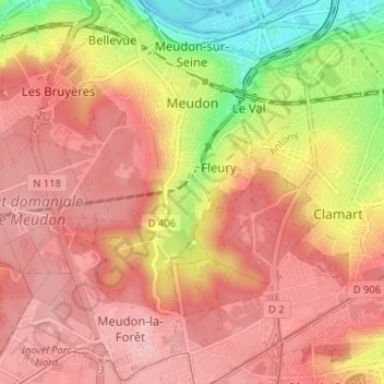
Nome: Mappa topografica Meudon, altitudine, rilievo.
Altitudine media: 132 m
Altitudine minima: 28 m
Altitudine massima: 187 m
Fai una donazione
Preparati per la tua prossima avventura:
In qualità di associato Amazon, questo sito riceve una commissione sugli acquisti idonei senza alcun costo aggiuntivo per te.