
Mappa topografica Much Hadham
Mappa interattiva
Clicca sulla mappa per visualizzare l'altitudine.
A proposito di questa mappa
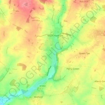
Nome: Mappa topografica Much Hadham, altitudine, rilievo.
Altitudine media: 80 m
Altitudine minima: 37 m
Altitudine massima: 116 m
Altre mappe topografiche
Clicca su una mappa per visualizzarne la topografia, l'altitudine e il rilievo.
Pelham Gate
United Kingdom > England > Hertfordshire > East Hertfordshire
Pelham Gate, Brent Pelham, East Hertfordshire, Hertfordshire, England, SG9 0HL, United Kingdom
Altitudine media: 113 m
Bishops Stortford Elsan Point
United Kingdom > England > Hertfordshire > East Hertfordshire
Bishops Stortford Elsan Point, East Hertfordshire, Hertfordshire, East of England, England, CM23 3BL, United Kingdom
Altitudine media: 78 m
Buntingford
United Kingdom > England > Hertfordshire > East Hertfordshire
Buntingford, East Hertfordshire, Hertfordshire, England, United Kingdom
Altitudine media: 110 m
Thorley
United Kingdom > England > Hertfordshire > East Hertfordshire > Thorley
Thorley, East Hertfordshire, Hertfordshire, East of England, England, United Kingdom
Altitudine media: 82 m