
Mappa topografica Cherwell District
Mappa interattiva
Clicca sulla mappa per visualizzare l'altitudine.
A proposito di questa mappa
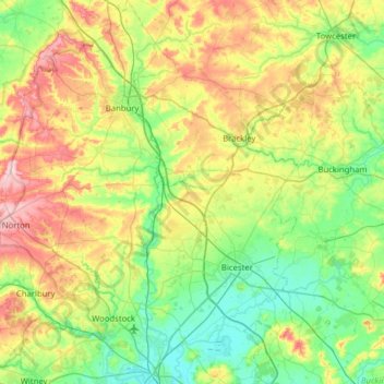
Nome: Mappa topografica Cherwell District, altitudine, rilievo.
Luogo: Cherwell District, Oxfordshire, England, United Kingdom (51.78096 -1.52284 52.16847 -1.04714)
Altitudine media: 116 m
Altitudine minima: 56 m
Altitudine massima: 240 m
Altre mappe topografiche
Clicca su una mappa per visualizzarne la topografia, l'altitudine e il rilievo.
Hornton
United Kingdom > England > Oxfordshire > Cherwell District
Hornton, Cherwell District, Oxfordshire, England, United Kingdom
Altitudine media: 172 m
Abingdon
United Kingdom > England > Oxfordshire > Vale of White Horse
Abingdon, Vale of White Horse, Oxfordshire, England, OX14 3UJ, United Kingdom
Altitudine media: 64 m
Juniper Hill
United Kingdom > England > Oxfordshire > Cherwell District > Cottisford
Juniper Hill, Cottisford, Cherwell District, Oxfordshire, England, NN13 5RN, United Kingdom
Altitudine media: 126 m
Wheatley
United Kingdom > England > Oxfordshire > South Oxfordshire
Wheatley, South Oxfordshire, Oxfordshire, England, United Kingdom
Altitudine media: 90 m
Bletchingdon
United Kingdom > England > Oxfordshire > Cherwell District
Bletchingdon, Cherwell District, Oxfordshire, England, United Kingdom
Altitudine media: 76 m
Roke
United Kingdom > England > Oxfordshire > South Oxfordshire > Berrick Salome
Roke, Berrick Salome, South Oxfordshire, Oxfordshire, England, OX10 6JE, United Kingdom
Altitudine media: 69 m
Bicester
United Kingdom > England > Oxfordshire > Cherwell District
Bicester, Cherwell District, Oxfordshire, England, United Kingdom
Altitudine media: 76 m
Burford
United Kingdom > England > Oxfordshire > West Oxfordshire > Fulbrook
Burford, Fulbrook, West Oxfordshire, Oxfordshire, England, United Kingdom
Altitudine media: 129 m
Thame
United Kingdom > England > Oxfordshire > South Oxfordshire
Thame, South Oxfordshire, Oxfordshire, England, United Kingdom
Altitudine media: 74 m
Duns Tew
United Kingdom > England > Oxfordshire > Cherwell District
Duns Tew, Cherwell District, Oxfordshire, England, United Kingdom
Altitudine media: 125 m
Wantage
United Kingdom > England > Oxfordshire > Vale of White Horse
Wantage, Vale of White Horse, Oxfordshire, England, United Kingdom
Altitudine media: 151 m
Oxford
United Kingdom > England > Oxfordshire > Oxford
Oxford, Oxfordshire, South East England, England, OX1 3HY, United Kingdom
Altitudine media: 81 m
Banbury
United Kingdom > England > Oxfordshire > Cherwell District
Banbury, Cherwell District, Oxfordshire, England, United Kingdom
Altitudine media: 116 m
East Hendred
United Kingdom > England > Oxfordshire > Vale of White Horse
East Hendred, Vale of White Horse, Oxfordshire, England, United Kingdom
Altitudine media: 119 m