
Fai una donazione
Preparati per la tua prossima avventura:
In qualità di associato Amazon, questo sito riceve una commissione sugli acquisti idonei senza alcun costo aggiuntivo per te.
Mappa topografica Sugarloaf Township
Clicca sulla mappa per visualizzare l'altitudine.
Fai una donazione
Preparati per la tua prossima avventura:
In qualità di associato Amazon, questo sito riceve una commissione sugli acquisti idonei senza alcun costo aggiuntivo per te.
Sugarloaf Township
Sugarloaf Township is located in the northeast corner of Columbia County, and is bordered to the north by Sullivan County and to the east by Luzerne County. Most of the township is rolling hills, with elevations ranging from 850 to 1,300 feet (260 to 400 m), while the northern part of the township contains the southern escarpment of the Allegheny Plateau, with elevations rising to 2,341 feet (714 m) along Huckleberry Mountain in the west, to 2,250 feet (690 m) on Central Mountain to the east, and to 2,360 feet (720 m) on Red Rock Mountain in the northeastern corner.
Fai una donazione
Preparati per la tua prossima avventura:
In qualità di associato Amazon, questo sito riceve una commissione sugli acquisti idonei senza alcun costo aggiuntivo per te.
A proposito di questa mappa
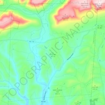
Nome: Mappa topografica Sugarloaf Township, altitudine, rilievo.
Altitudine media: 393 m
Altitudine minima: 251 m
Altitudine massima: 742 m
Fai una donazione
Preparati per la tua prossima avventura:
In qualità di associato Amazon, questo sito riceve una commissione sugli acquisti idonei senza alcun costo aggiuntivo per te.
Altre mappe topografiche
Clicca su una mappa per visualizzarne la topografia, l'altitudine e il rilievo.
Mifflin Cross Roads
United States > Pennsylvania > Columbia County > Beaver Township
Altitudine media: 312 m
Fai una donazione
Preparati per la tua prossima avventura:
In qualità di associato Amazon, questo sito riceve una commissione sugli acquisti idonei senza alcun costo aggiuntivo per te.
Byrnesville
United States > Pennsylvania > Columbia County > Conyngham Township
Altitudine media: 404 m
Hemlock Creek
United States > Pennsylvania > Columbia County > Buckhorn > Buckhorn
Altitudine media: 207 m