
Fai una donazione
Preparati per la tua prossima avventura:
In qualità di associato Amazon, questo sito riceve una commissione sugli acquisti idonei senza alcun costo aggiuntivo per te.
Mappa topografica Goslar
Clicca sulla mappa per visualizzare l'altitudine.
Fai una donazione
Preparati per la tua prossima avventura:
In qualità di associato Amazon, questo sito riceve una commissione sugli acquisti idonei senza alcun costo aggiuntivo per te.
Goslar
Goslar is situated in the middle of the upper half of Germany, about 40 kilometres (25 miles) south of Brunswick and about 70 km (43 mi) southeast of the state capital, Hanover. The Schalke mountain is the highest elevation within the municipal boundaries at 762 metres (2,500 feet). The lowest point of 175 m (574 ft) is near the Oker river. Geographically, Goslar forms the boundary between the Hildesheim Börde which is part of the Northern German Plain, and the Harz range, which is the highest, northernmost extension of Germany's Central Uplands. The Hildesheim Börde is characterised by plains with rich clay soils – used agriculturally for sugar beet farming – interlaced with several hill ranges commonly known as the Hildesheim Forest and Salzgitter Hills. In the northeast the Harly Forest stretches down to the River Oker, in the east, Goslar borders on the German state of Saxony-Anhalt.
Fai una donazione
Preparati per la tua prossima avventura:
In qualità di associato Amazon, questo sito riceve una commissione sugli acquisti idonei senza alcun costo aggiuntivo per te.
A proposito di questa mappa
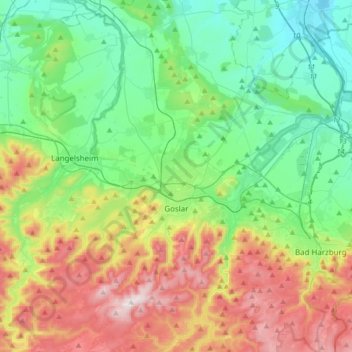
Nome: Mappa topografica Goslar, altitudine, rilievo.
Luogo: Goslar, Landkreis Goslar, Lower Saxony, Germany (51.84398 10.31590 52.00593 10.65119)
Altitudine media: 312 m
Altitudine minima: 91 m
Altitudine massima: 762 m
Fai una donazione
Preparati per la tua prossima avventura:
In qualità di associato Amazon, questo sito riceve una commissione sugli acquisti idonei senza alcun costo aggiuntivo per te.
Altre mappe topografiche
Clicca su una mappa per visualizzarne la topografia, l'altitudine e il rilievo.