
Mappa topografica Cartaxo
Mappa interattiva
Clicca sulla mappa per visualizzare l'altitudine.
A proposito di questa mappa
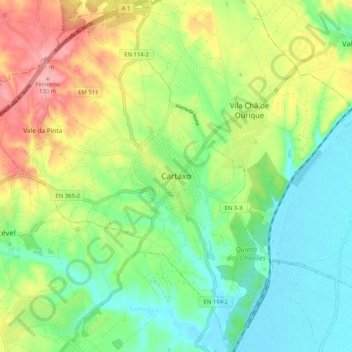
Nome: Mappa topografica Cartaxo, altitudine, rilievo.
Altitudine media: 50 m
Altitudine minima: 1 m
Altitudine massima: 130 m
In the middle of the 19th century, Cartaxo was one of the more populated areas of Estremadura, in the Comarca of Santarém, with just over 200 inhabitants. On the death of King John IV of Portugal, his testament granted several "honours" to his daughter (in 1656). On 10 December 1815, by royal decree from Rio de Janeiro, King John VI granted it administrative independence, followed up on 21 June 1995 with its elevation to the status of city.