
Fai una donazione
Preparati per la tua prossima avventura:
In qualità di associato Amazon, questo sito riceve una commissione sugli acquisti idonei senza alcun costo aggiuntivo per te.
Mappa topografica Kula
Clicca sulla mappa per visualizzare l'altitudine.
Fai una donazione
Preparati per la tua prossima avventura:
In qualità di associato Amazon, questo sito riceve una commissione sugli acquisti idonei senza alcun costo aggiuntivo per te.
Kula
Kula is a census-designated place (CDP) of Maui, Hawaii. It stretches across Upcountry Maui, the western-facing slopes of Haleakalā. Most residential areas lie between about 500 to 1,100 m (1,600 to 3,600 ft) in elevation. The district is distinct from the generally hotter and busier coastal areas. The population of the Kula CDP at the 2020 Census was 6,942, while the larger Kula Census County Division, which includes the communities of upland Keokea and coastal Wailea and Makena, had a population of 12,864.
Fai una donazione
Preparati per la tua prossima avventura:
In qualità di associato Amazon, questo sito riceve una commissione sugli acquisti idonei senza alcun costo aggiuntivo per te.
A proposito di questa mappa
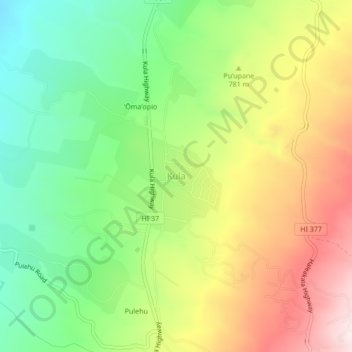
Nome: Mappa topografica Kula, altitudine, rilievo.
Luogo: Kula, Maui County, Hawaii, United States (20.77203 -156.34371 20.81203 -156.30371)
Altitudine media: 740 m
Altitudine minima: 473 m
Altitudine massima: 1.089 m
Fai una donazione
Preparati per la tua prossima avventura:
In qualità di associato Amazon, questo sito riceve una commissione sugli acquisti idonei senza alcun costo aggiuntivo per te.
Altre mappe topografiche
Clicca su una mappa per visualizzarne la topografia, l'altitudine e il rilievo.
Maui
United States > Hawaii > Maui County
Maui County's topography is characterized by a dramatic blend of volcanic mountains, rolling hills, and stunning coastal regions, creating a diverse landscape that contributes to its unique beauty. The island's centerpiece is Haleakalā, a massive shield volcano rising to an elevation of 10,023 feet, which is…
Altitudine media: 232 m
Molokai
United States > Hawaii > Maui County
The eastern half of the island is a high plateau rising up to an elevation of 4,900 ft (1,500 m) on Kamakou peak and includes the 2,774-acre (11.23 km2; 4.334 mi2) Molokai Forest Reserve. The eastern half is covered with lush wet forests that get more than 300 in (7,600 mm) of rain per year. The high-elevation…
Altitudine media: 66 m
Fai una donazione
Preparati per la tua prossima avventura:
In qualità di associato Amazon, questo sito riceve una commissione sugli acquisti idonei senza alcun costo aggiuntivo per te.
Fai una donazione
Preparati per la tua prossima avventura:
In qualità di associato Amazon, questo sito riceve una commissione sugli acquisti idonei senza alcun costo aggiuntivo per te.
Haleakalā National Park
United States > Hawaii > Maui County
At its lowest, near the ocean, the National Park has a tropical rainforest climate bordering a tropical monsoon climate. However, as altitudes progresses the climate becomes oceanic/Mediterranean, reaching, at the very top of Haleakalā, an alpine climate.
Altitudine media: 949 m
Lānaʻi
United States > Hawaii > Maui County
The highest point in Lanai is Mount Lānaʻihale. It is an inactive volcano near the center of the island and to the east of Lanai City. The elevation of Mount Lānaʻihale is 3,366 ft (1,026 m).
Altitudine media: 162 m
Fai una donazione
Preparati per la tua prossima avventura:
In qualità di associato Amazon, questo sito riceve una commissione sugli acquisti idonei senza alcun costo aggiuntivo per te.
Fai una donazione
Preparati per la tua prossima avventura:
In qualità di associato Amazon, questo sito riceve una commissione sugli acquisti idonei senza alcun costo aggiuntivo per te.
Maui
United States > Hawaii > Maui County
Maui's diverse landscapes are the result of a unique combination of geology, topography, and climate. Each volcanic cone in the chain of the Hawaiian Islands is built of dark, iron-rich/quartz-poor rocks, which poured out of thousands of vents as highly fluid lava throughout millions of years. Several of the…
Altitudine media: 232 m
Maui
United States > Hawaii > Maui County
The climate is characterized by a two-season year, tropical and uniform temperatures at any given elevation, geographic differences in rainfall, high relative humidity, extensive cloud formations (except on the leeward coasts and at the highest elevations), and dominant trade wind flow (especially at lower…
Altitudine media: 232 m
Haleakalā National Park
United States > Hawaii > Maui County
At its lowest, near the ocean, the National Park has a tropical rainforest climate bordering a tropical monsoon climate. However, as altitudes progresses the climate becomes oceanic/Mediterranean, reaching, at the very top of Haleakalā, an alpine climate.
Altitudine media: 949 m
Fai una donazione
Preparati per la tua prossima avventura:
In qualità di associato Amazon, questo sito riceve una commissione sugli acquisti idonei senza alcun costo aggiuntivo per te.
Molokini Shoal Marine Life Conservation District
United States > Hawaii > Maui County
Altitudine media: 0 m
Fai una donazione
Preparati per la tua prossima avventura:
In qualità di associato Amazon, questo sito riceve una commissione sugli acquisti idonei senza alcun costo aggiuntivo per te.
Maui
United States > Hawaii > Maui County
Maui's diverse landscapes are the result of a unique combination of geology, topography, and climate. Each volcanic cone in the chain of the Hawaiian Islands is built of dark, iron-rich/quartz-poor rocks, which poured out of thousands of vents as highly fluid lava throughout millions of years. Several of the…
Altitudine media: 232 m
Molokai
United States > Hawaii > Maui County
The eastern half of the island is a high plateau rising up to an elevation of 4,900 ft (1,500 m) on Kamakou peak and includes the 2,774-acre (11.23 km2; 4.334 mi2) Molokai Forest Reserve. The eastern half is covered with lush wet forests that get more than 300 in (7,600 mm) of rain per year. The high-elevation…
Altitudine media: 66 m
Fai una donazione
Preparati per la tua prossima avventura:
In qualità di associato Amazon, questo sito riceve una commissione sugli acquisti idonei senza alcun costo aggiuntivo per te.
Lānaʻi
United States > Hawaii > Maui County
The highest point in Lanai is Mount Lānaʻihale. It is an inactive volcano near the center of the island and to the east of Lanai City. The elevation of Mount Lānaʻihale is 3,366 ft (1,026 m).
Altitudine media: 162 m
Lānaʻi
United States > Hawaii > Maui County
The highest point in Lanai is Mount Lānaʻihale. It is an inactive volcano near the center of the island and to the east of Lanai City. The elevation of Mount Lānaʻihale is 3,366 ft (1,026 m).
Altitudine media: 162 m
Fai una donazione
Preparati per la tua prossima avventura:
In qualità di associato Amazon, questo sito riceve una commissione sugli acquisti idonei senza alcun costo aggiuntivo per te.