
Fai una donazione
Preparati per la tua prossima avventura:
In qualità di associato Amazon, questo sito riceve una commissione sugli acquisti idonei senza alcun costo aggiuntivo per te.
Mappa topografica Monument
Clicca sulla mappa per visualizzare l'altitudine.
Fai una donazione
Preparati per la tua prossima avventura:
In qualità di associato Amazon, questo sito riceve una commissione sugli acquisti idonei senza alcun costo aggiuntivo per te.
Monument
Monument is situated at an elevation of approximately 7,000 feet (2,134 meters) within the Front Range of the Rocky Mountains, creating a diverse topography that is both striking and varied. The town is characterized by rolling hills and flat terrain in the valley, contrasted by the rugged foothills of the Rockies that rise dramatically to the west. This landscape is further defined by nearby geological features, including Monument Rock, a prominent natural landmark that towers above the area. The surrounding environment includes wooded areas, grasslands, and proximity to the Pike National Forest, making it a hub for outdoor activities such as hiking, fishing, and camping. The mixture of elevations and natural formations offers both residents and visitors stunning vistas and a variety of recreational opportunities.
Fai una donazione
Preparati per la tua prossima avventura:
In qualità di associato Amazon, questo sito riceve una commissione sugli acquisti idonei senza alcun costo aggiuntivo per te.
A proposito di questa mappa
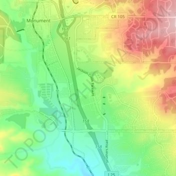
Nome: Mappa topografica Monument, altitudine, rilievo.
Luogo: Monument, El Paso County, Colorado, United States (39.04222 -104.88119 39.09819 -104.84331)
Altitudine media: 2.133 m
Altitudine minima: 2.035 m
Altitudine massima: 2.283 m
Fai una donazione
Preparati per la tua prossima avventura:
In qualità di associato Amazon, questo sito riceve una commissione sugli acquisti idonei senza alcun costo aggiuntivo per te.