
Mappa topografica Barron River
Mappa interattiva
Clicca sulla mappa per visualizzare l'altitudine.
A proposito di questa mappa
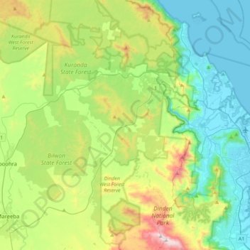
Nome: Mappa topografica Barron River, altitudine, rilievo.
Altitudine media: 360 m
Altitudine minima: 0 m
Altitudine massima: 1.284 m
The Barron's headwaters start in the Mount Hypipamee National Park near Mount Hypipamee at an elevation of 1,200 metres (3,900 ft). The river then flows north 65 kilometres (40 mi) across the Atherton Tablelands before finally turning east after Mareeba towards Kuranda. After passing under the Kuranda Range Highway's bridge and through Kuranda proper, it descends down the 260-metre (850 ft)-high Barron Falls and reaches the Cairns floodplains near Smithfield. The Dinner Falls are located along the upper Barron River.
Altre mappe topografiche
Clicca su una mappa per visualizzarne la topografia, l'altitudine e il rilievo.
Biboohra
Australia > Queensland > Biboohra
Biboohra, Mareeba Shire, Queensland, Australia
Altitudine media: 393 m