
Mappa topografica Whidbey Island
Mappa interattiva
Clicca sulla mappa per visualizzare l'altitudine.
Whidbey Island
Whidbey Island features a diverse topography characterized by a mix of rolling hills, lush forests, and dramatic coastal cliffs. The island stretches approximately 55 miles in length and up to 12 miles wide, rising to elevations of about 500 feet at its highest point. Its terrain includes expansive farmland and rugged shorelines, interspersed with sandy beaches and rocky outcrops along the Puget Sound. Deception Pass, a notable feature, consists of steep cliffs and a narrow strait that offers stunning views and is bridged by the iconic Deception Pass Bridge. The varied landscape supports a rich ecosystem, making it a haven for outdoor activities like hiking, kayaking, and wildlife observation.
A proposito di questa mappa
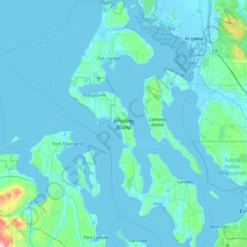
Nome: Mappa topografica Whidbey Island, altitudine, rilievo.
Luogo: Whidbey Island, Island County, Washington, United States (47.90492 -122.76999 48.41132 -122.34936)
Altitudine media: 45 m
Altitudine minima: -4 m
Altitudine massima: 993 m