
Mappa topografica Shepperton
Mappa interattiva
Clicca sulla mappa per visualizzare l'altitudine.
A proposito di questa mappa
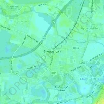
Nome: Mappa topografica Shepperton, altitudine, rilievo.
Altitudine media: 12 m
Altitudine minima: 7 m
Altitudine massima: 23 m
Shepperton has a long boundary with the River Thames in its southernmost salient, which almost surrounds Spelthorne. Old Shepperton is almost surrounded by the extreme southern meander within this. Prehistoric glacial retreat north of this has made the north bank almost flat for a considerable distance and as such, elevation never exceeds 14 m above mean sea level (on the border of Laleham). The river never exceeds 11.5 m, (beside Dumsey Meadow and under Chertsey Bridge). The lowest elevation is 9 m in flood meadows at the confluence of the Ash with the Thames. The Ash is the border with Littleton and Sunbury-on-Thames (mostly, to the northeast, with its technical hamlet, Upper Halliford).
Altre mappe topografiche
Clicca su una mappa per visualizzarne la topografia, l'altitudine e il rilievo.
Charlton
United Kingdom > England > Surrey > Borough of Spelthorne
Charlton, Borough of Spelthorne, Surrey, England, TW17 0ST, United Kingdom
Altitudine media: 13 m
Laleham
United Kingdom > England > Surrey > Borough of Spelthorne
Laleham, Borough of Spelthorne, Surrey, England, TW18 1SD, United Kingdom
Altitudine media: 14 m
Upper Halliford
United Kingdom > England > Surrey > Borough of Spelthorne
Upper Halliford, Borough of Spelthorne, Surrey, England, TW17 8SQ, United Kingdom
Altitudine media: 13 m
Pharaoh's Island
United Kingdom > England > Surrey > Borough of Spelthorne
Pharaoh's Island, Borough of Spelthorne, Surrey, England, TW17 9LN, United Kingdom
Altitudine media: 14 m
Ashford
United Kingdom > England > Surrey > Borough of Spelthorne
Ashford, Borough of Spelthorne, Surrey, England, United Kingdom
Altitudine media: 16 m
Stanwell
United Kingdom > England > Surrey > Borough of Spelthorne
Stanwell, Borough of Spelthorne, Surrey, England, TW19 7EB, United Kingdom
Altitudine media: 20 m