
Mappa topografica Falmouth
Mappa interattiva
Clicca sulla mappa per visualizzare l'altitudine.
Falmouth
Falmouth's topography is similar to the rest of Cape Cod's, with many small ponds, creeks, and inlets surrounded by the pines and oaks of the Cape and often rocky beachfront. Falmouth's southern shore is notable for a series of ponds and rivers spaced very closely together, all of which travel some distance into the town. These include, from west to east, Falmouth Inner Harbor, Little Pond, Great Pond (which leads to the Dexter and Coonamesset rivers), Green Pond, Bourne's Pond, Eel Pond (which leads to the Childs River), and Waquoit Bay, which lies along the Mashpee town line. The Buzzards Bay side of the town is primarily bays divided by necks, peninsulas connected to land by isthmi. The largest inlet is Megansett Cove along the Bourne town line. The Buzzards Bay shore of Falmouth is punctuated by a number of hamlets, including, from north to south, Megansett, New Silver Beach, Old Silver, Chappaquoit, Sippewisset, Quissett, and Woods Hole.
A proposito di questa mappa
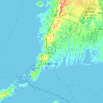
Nome: Mappa topografica Falmouth, altitudine, rilievo.
Luogo: Falmouth, Barnstable County, Massachusetts, United States (41.48914 -70.76063 41.66039 -70.49800)
Altitudine media: 7 m
Altitudine minima: -19 m
Altitudine massima: 72 m
Altre mappe topografiche
Clicca su una mappa per visualizzarne la topografia, l'altitudine e il rilievo.
Opeechee Heights Beach
United States > Massachusetts > Barnstable County > Barnstable > Centerville
Altitudine media: 14 m
West Barnstable
United States > Massachusetts > Barnstable County > West Barnstable
Altitudine media: 15 m
Washburn Island
United States > Massachusetts > Barnstable County > Falmouth > Menauhant
Altitudine media: 1 m
Dennis Port
United States > Massachusetts > Barnstable County > Dennis > Dennis Port
Altitudine media: 3 m
Bournedale
United States > Massachusetts > Barnstable County > Bourne > Bournedale
Altitudine media: 29 m
Barnstable
United States > Massachusetts > Barnstable County > Barnstable > Barnstable
Altitudine media: 10 m