
Mappa topografica Thousand Oaks
Mappa interattiva
Clicca sulla mappa per visualizzare l'altitudine.
Thousand Oaks
The northern parts consist of mountainous terrain in the Simi Hills, Conejo Mountains and Mount Clef Ridge. Narrow canyons such as Hill Canyon cut through the steeper mountainous areas. Conejo Mountain and Conejo Grade are found in westernmost Newbury Park, while the southernmost parts of Thousand Oaks are made up of Russell Valley, Hidden Valley and the steep rugged slopes of the Santa Monica Mountains. The elevation ranges from 500 feet in the northwest to the 2,403 feet Simi Peak. The major drainage is Conejo Creek (Arroyo Conejo).
A proposito di questa mappa
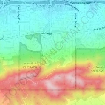
Nome: Mappa topografica Thousand Oaks, altitudine, rilievo.
Luogo: Thousand Oaks, Ventura County, California, United States (34.17084 -118.91146 34.17228 -118.90929)
Altitudine media: 303 m
Altitudine minima: 191 m
Altitudine massima: 486 m
Altre mappe topografiche
Clicca su una mappa per visualizzarne la topografia, l'altitudine e il rilievo.
Newbury Park
United States > California > Ventura County > Thousand Oaks
Newbury Park can be described as a town,[6] community,[94] or section[9] mostly within the Thousand Oaks city limits in addition to rural areas west of Thousand Oaks. Newbury Park is bordered by Lynn Road in the east and the Conejo Grade on the west. It borders the Santa Monica Mountains in the south, while…
Altitudine media: 262 m
Ventu Park
United States > California > Ventura County > Thousand Oaks > Newbury Park
Altitudine media: 250 m