
Mappa topografica Shropshire Hills National Landscape
Mappa interattiva
Clicca sulla mappa per visualizzare l'altitudine.
Shropshire Hills National Landscape
The Shropshire Hills, located in the Welsh Marches, are relatively high: the highest point in the county, Brown Clee Hill, near Ludlow, has an altitude of 540 metres (1,772 ft). This gives Shropshire the 13th highest hill per county in England. Titterstone Clee Hill, part of the Clee Hills, is nearly as high as Brown Clee, at 533 metres (1,749 ft), making it the third highest hill in the county. The Stiperstones are the second highest, at 536 metres (1,759 ft), and are notable for their tors of quartzite; particularly notable are Devil's Chair (SO368991) and Shepherd's Rock (SO373998).
A proposito di questa mappa
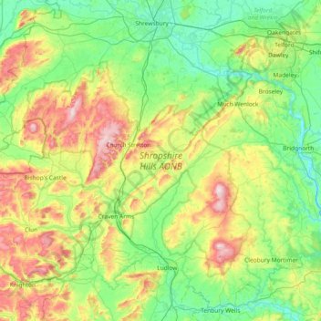
Nome: Mappa topografica Shropshire Hills National Landscape, altitudine, rilievo.
Altitudine media: 171 m
Altitudine minima: 26 m
Altitudine massima: 530 m
Altre mappe topografiche
Clicca su una mappa per visualizzarne la topografia, l'altitudine e il rilievo.
Minton
United Kingdom > England > Shropshire > Church Stretton > Little Stretton
Altitudine media: 272 m
Melverley Green
United Kingdom > England > Shropshire > Melverley > Melverley Green
Altitudine media: 60 m