
Mappa topografica Bella Coola
Mappa interattiva
Clicca sulla mappa per visualizzare l'altitudine.
A proposito di questa mappa
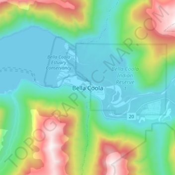
Nome: Mappa topografica Bella Coola, altitudine, rilievo.
Altitudine media: 437 m
Altitudine minima: -1 m
Altitudine massima: 1.609 m
There is a 454 km mostly paved road connection by Highway 20 to Williams Lake. The road was built in 1953 by local residents, and features a 15 km ascent from the Valley floor to the Chilcotin plateau, gaining 1600m in elevation to the summit at Heckman Pass, via a number of steep grades & switchbacks. The construction of this road was described in the books "Bella Coola" and "A Road Runs West".