
Mappa topografica Martha's Vineyard
Mappa interattiva
Clicca sulla mappa per visualizzare l'altitudine.
Martha's Vineyard
Martha's Vineyard features a diverse topography characterized by gently rolling hills, sandy beaches, and rugged coastline. The island spans approximately 100 square miles and boasts elevations that reach up to 289 feet at its highest point, offering panoramic views of the surrounding Atlantic Ocean. The terrain is dotted with woodlands, meadows, and wetlands, creating a variety of ecosystems that support a rich array of wildlife. Coastal bluffs and cliffs, particularly along the southern shore, provide dramatic scenery and are shaped by both natural erosion and the forces of the ocean. The island's numerous ponds and inlets add to its scenic beauty, making it a unique blend of maritime and terrestrial landscapes.
A proposito di questa mappa
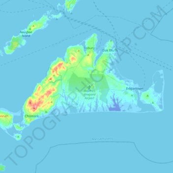
Nome: Mappa topografica Martha's Vineyard, altitudine, rilievo.
Altitudine media: 3 m
Altitudine minima: -21 m
Altitudine massima: 85 m
Altre mappe topografiche
Clicca su una mappa per visualizzarne la topografia, l'altitudine e il rilievo.