
Mappa topografica Santa Barbara
Mappa interattiva
Clicca sulla mappa per visualizzare l'altitudine.
Santa Barbara
Annual rainfall totals are highly variable and in exceptional years like 1940–1941 and 1997–1998 over 40 inches (1.0 m) of rain have fallen in a year, but in dry seasons less than 6 inches (150 mm) is not unheard of. Snow sometimes covers higher elevations of the Santa Ynez Mountains but is extremely rare in the city itself. The most recent accumulating snow to fall near sea level was in January 1949, when approximately 2 inches (5.1 cm) fell in the city.
A proposito di questa mappa
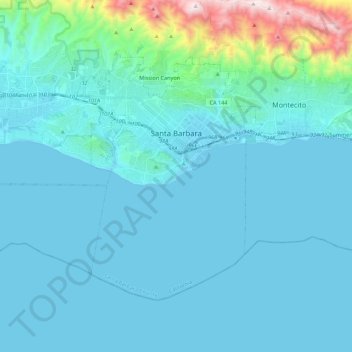
Nome: Mappa topografica Santa Barbara, altitudine, rilievo.
Altitudine media: 119 m
Altitudine minima: -1 m
Altitudine massima: 1.155 m
Altre mappe topografiche
Clicca su una mappa per visualizzarne la topografia, l'altitudine e il rilievo.
North Santa Maria
United States > California > Santa Barbara County > Santa Maria
Altitudine media: 65 m
Jalama Beach County Park
United States > California > Santa Barbara County > Jalama
Altitudine media: 40 m
Shoreline Park
United States > California > Santa Barbara County > Santa Barbara
Altitudine media: 21 m
Las Positas Meadows
United States > California > Santa Barbara County > Santa Barbara
Altitudine media: 66 m