Mappa topografica Jammu
Mappa interattiva
Clicca sulla mappa per visualizzare l'altitudine.
A proposito di questa mappa
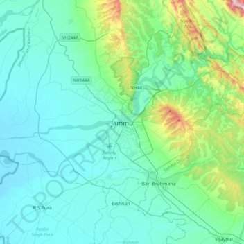
Nome: Mappa topografica Jammu, altitudine, rilievo.
Luogo: Jammu, Jammu District, Jammu and Kashmir, 180001, India (32.55856 74.69809 32.87856 75.01809)
Altitudine media: 367 m
Altitudine minima: 255 m
Altitudine massima: 987 m
Jammu is located at 32°44′N 74°52′E / 32.73°N 74.87°E / 32.73; 74.87. It has an average elevation of 300 m (980 ft). Jammu city lies at uneven ridges of low heights at the Shivalik hills. It is surrounded by the Shivalik range to the north, east, and southeast while the Trikuta Range surrounds it in the northwest. It is approximately 600 kilometres (370 mi) from the national capital, New Delhi.