Geolocalizza

Mappa topografica Maharashtra

Mappa interattiva

Clicca sulla mappa per visualizzare l'altitudine.

A proposito di questa mappa

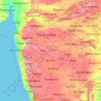
Nome: Mappa topografica Maharashtra, altitudine, rilievo.

Luogo: Maharashtra, India (15.60636 72.65261 22.03025 80.89778)

Altitudine media: 346 m

Altitudine minima: -1 m

Altitudine massima: 1.418 m

Maharashtra with a total area of 307,713 km2 (118,809 sq mi), is the third-largest state by area in terms of land area and constitutes 9.36 per cent of India's total geographical area. The State lies between 15°35' N to 22°02' N latitude and 72°36' E to 80°54' E longitude. It occupies the western and central part of the country and has a coastline stretching 840 kilometres along the Arabian Sea. The dominant physical feature of the state is its plateau character, which is separated from the Konkan coastline by the mountain range of the Western Ghats, which runs parallel to the coast from north to south.The Western Ghats, also known as the Sahyadri Range, has an average elevation of 1,200 metres (4,000 ft); its slopes gently descending towards the east and southeast. The Western Ghats (or the Sahyadri Mountain range) provide a physical barrier to the state on the west, while the Satpura Hills along the north and Bhamragad-Chiroli-Gaikhuri ranges on the east serve as its natural borders. This state's expansion from North to South is 700 km and East to West is 800 km. To the west of these hills lie the Konkan coastal plains, 50–80 kilometres in width. To the east of the Ghats lies the flat Deccan Plateau. The main rivers of the state are the Krishna, and its tributary, Bhima, the Godavari, and its main tributaries, Manjara, and Wardha-Wainganga and the Tapi, and its tributary Purna. Maharashtra is divided into five geographic regions. Konkan is the western coastal region, between the Western Ghats and the sea. Khandesh is the north region lying in the valley of the Tapti, Purna river. Nashik, Malegaon Jalgaon, Dhule and Bhusawal are the major cities of this region. Desh is in the center of the state. Marathwada, which was a part of the princely state of Hyderabad until 1956, is located in the southeastern part of the state. Aurangabad and Nanded are the main cities of the region. Vidarbha is the easternmost region of the state, formerly part of the Central Provinces and Berar.

Wikipedia (CC-BY-SA 3.0)

Altre mappe topografiche

Clicca su una mappa per visualizzarne la topografia, l'altitudine e il rilievo.

Bengaluru

India > Karnataka > Bangalore North

Bengaluru, Bangalore North, Bengaluru Urban District, Karnataka, India

Altitudine media: 881 m

3d

India > Rajasthan > Ganganagar Tehsil > 1 LNP

3d, 1 LNP, Ganganagar Tehsil, Sri Ganganagar District, Rajasthan, India

Altitudine media: 178 m

Chennai

India > Tamil Nadu > Chennai

Chennai, Chennai District, Tamil Nadu, India

Altitudine media: 8 m

Tamil Nadu

India

Tamil Nadu, India

Altitudine media: 253 m

Punjab

India

Punjab, India

Altitudine media: 477 m

Odisha

India

Odisha, India

Altitudine media: 227 m

Srinagar

India > Jammu and Kashmir > Srinagar (South)

Srinagar, Srinagar (South), Srinagar District, Jammu and Kashmir, 190001, India

Altitudine media: 1.805 m

Karnataka

India

Karnataka, India

Altitudine media: 386 m

Kerala

India

Kerala, India

Altitudine media: 251 m

Ahmedabad

India > Gujarat

Ahmedabad, Ahmedabad City Taluka, Ahmedabad District, Gujarat, 380001, India

Altitudine media: 50 m

Mysuru

India > Karnataka > Mysuru taluk

Mysuru, Mysuru taluk, Mysuru District, Karnataka, 570001, India

Altitudine media: 727 m

Ladakh

India

Ladakh, India

Altitudine media: 4.726 m

Telangana

India

Telangana, India

Altitudine media: 320 m

Pune

India > Maharashtra > Pune City > Pune

Pune, Pune City, Pune District, Maharashtra, 411001, India

Altitudine media: 641 m

West Bengal

India

West Bengal, India

Altitudine media: 182 m

Prayagraj

India > Uttar Pradesh > Prayagraj

Prayagraj, Prayagraj District, Uttar Pradesh, 211001, India

Altitudine media: 91 m

Jammu and Kashmir

India

Jammu and Kashmir, India

Altitudine media: 2.430 m

Jagdevpur mandal

India > Telangana

Jagdevpur mandal, Siddipet District, Telangana, India

Altitudine media: 537 m

Suryanelli

India > Kerala > Udumbanchola

Suryanelli, Udumbanchola, Idukki District, Kerala, India

Altitudine media: 1.553 m

Chennai District

India > Tamil Nadu

Chennai District, Tamil Nadu, India

Altitudine media: 9 m

Bachupally mandal

India > Telangana

Bachupally mandal, Medchal–Malkajgiri District, Telangana, 500090, India

Altitudine media: 593 m

Andhra Pradesh

India

Andhra Pradesh, India

Altitudine media: 269 m

Murbad

India > Maharashtra > Murbad Taluka > Murbad

Murbad, Murbad Taluka, Thane District, Maharashtra, India

Altitudine media: 91 m

Bihar

India

Bihar, India

Altitudine media: 606 m

New Delhi

India > Delhi

New Delhi, Delhi, India

Altitudine media: 230 m

Uttarakhand

India > Uttarakhand

Uttarakhand, India

Altitudine media: 2.102 m

Himachal Pradesh

India

Himachal Pradesh, India

Altitudine media: 2.869 m

Rajasthan

India

Rajasthan, India

Altitudine media: 254 m

Kodangal

India > Telangana > Kodangal mandal

Kodangal, Kodangal mandal, Vikarabad District, Telangana, 509338, India

Altitudine media: 553 m

Pallikara

India > Kerala > Hosdurg > Pallikere > Ambalathigal

Pallikara, Ambalathigal, Pallikere, Hosdurg, Kasaragod District, Kerala, India

Altitudine media: 18 m

Mumbai City

India > Maharashtra

Mumbai City, Maharashtra, India

Altitudine media: 3 m

Whitefield

India > Karnataka > Bangalore East > Bengaluru

Whitefield, Bengaluru, Bangalore East, Bengaluru Urban District, Karnataka, 560066, India

Altitudine media: 875 m

Gurgaon

India > Haryana > Gurugram District

Gurgaon, Gurugram District, Haryana, India

Altitudine media: 237 m

Hyderabad

India > Telangana

Hyderabad, Telangana, India

Altitudine media: 534 m

Kodaikanal

India > Tamil Nadu

Kodaikanal, Dindigul District, Tamil Nadu, India

Altitudine media: 869 m

Haryana

India

Haryana, India

Altitudine media: 281 m

Meghalaya

India

Meghalaya, India

Altitudine media: 244 m

Assam

India

Assam, India

Altitudine media: 1.142 m

Andaman and Nicobar Islands

India

Andaman and Nicobar Islands, India

Altitudine media: 1 m

Jharkhand

India

Jharkhand, India

Altitudine media: 277 m

Sikkim

India

Sikkim, India

Altitudine media: 3.786 m

Ranchi

India > Jharkhand > Kanke

Ranchi, Kanke, Ranchi District, Jharkhand, 834001, India

Altitudine media: 648 m

Vijayawada

India > Andhra Pradesh > Vijayawada (Urban)

Vijayawada, Vijayawada (Urban), NTR District, Andhra Pradesh, 520001, India

Altitudine media: 36 m

Nashik

India > Maharashtra > Nashik

Nashik, Maharashtra, India

Altitudine media: 555 m

Jaipur

India > Rajasthan > Jaipur Tehsil

Jaipur, Jaipur Municipal Corporation, Jaipur Tehsil, Jaipur District, Rajasthan, 302001, India

Altitudine media: 408 m

Kolkata

India > West Bengal

Kolkata, Kolkata District, West Bengal, 700073, India

Altitudine media: 5 m

Sultanpur Lodhi

India > Punjab > Sultanpur Lodhi Tahsil

Sultanpur Lodhi, Sultanpur Lodhi Tahsil, Kapurthala District, Punjab, 144626, India

Altitudine media: 214 m

Kapurthala

India > Punjab

Kapurthala, Kapurthala District, Punjab, India

Altitudine media: 242 m

Banjar

India > Himachal Pradesh > Bhuntar

Banjar, Bhuntar, Kullu District, Himachal Pradesh, 175125, India

Altitudine media: 1.271 m

Pallapalayam - Kannampalayam Canal

India > Tamil Nadu > Sulur > Kannampalayam

Pallapalayam - Kannampalayam Canal, Papampatti Pirivu, Kannampalayam, Sulur, Coimbatore District, Tamil Nadu, 641402, India

Altitudine media: 381 m