
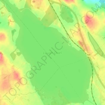
Mappa topografica Lough Owel
Mappa interattiva
Clicca sulla mappa per visualizzare l'altitudine.
A proposito di questa mappa
Nome: Mappa topografica Lough Owel, altitudine, rilievo.
Altitudine media: 105 m
Altitudine minima: 66 m
Altitudine massima: 152 m
Altre mappe topografiche
Clicca su una mappa per visualizzarne la topografia, l'altitudine e il rilievo.
Lough Bane
Lough Bane, Crosskeys ED, The Municipal District of Kells, County Westmeath, County Meath, Leinster, Ireland
Altitudine media: 130 m
Rathwire
Rathwire, The Municipal District of Mullingar — Kinnegad, County Westmeath, Leinster, Ireland
Altitudine media: 94 m
Ardnurcher
Ardnurcher, Streamstown ED, The Municipal District of Athlone — Moate, County Westmeath, Leinster, Ireland
Altitudine media: 71 m
Athlone
Ireland > County Westmeath > Athlone
Athlone, The Municipal District of Athlone — Moate, County Westmeath, Leinster, N37 N1F2, Ireland
Altitudine media: 44 m
Fore
Fore, The Municipal District of Mullingar — Kinnegad, County Westmeath, Leinster, N91 TY06, Ireland
Altitudine media: 110 m
Lough Sewdy
Lough Sewdy, Ballymore ED, The Municipal District of Athlone — Moate, County Westmeath, Leinster, Ireland
Altitudine media: 86 m
Kilbixy
Kilbixy, Kilbixy ED, The Municipal District of Athlone — Moate, County Westmeath, Leinster, Ireland
Altitudine media: 67 m
Ballyloughloe
Ballyloughloe, The Municipal District of Athlone — Moate, County Westmeath, Leinster, N37 C4A0, Ireland
Altitudine media: 72 m
Tyrrellspass
Tyrrellspass, The Municipal District of Athlone — Moate, County Westmeath, Leinster, Ireland
Altitudine media: 100 m
Dysart
Dysart, Bracklin ED, The Municipal District of Mullingar — Kinnegad, County Westmeath, Leinster, Ireland
Altitudine media: 84 m
Castletown Geoghegan
Castletown Geoghegan, Castletown ED, The Municipal District of Athlone — Moate, County Westmeath, Leinster, Ireland
Altitudine media: 96 m
Streamstown
Streamstown, The Municipal District of Athlone — Moate, County Westmeath, Leinster, Ireland
Altitudine media: 105 m
Glassan
Glassan, Glassan ED, The Municipal District of Athlone — Moate, County Westmeath, Leinster, Ireland
Altitudine media: 57 m
Lough Bane
Lough Bane, Knockarrow ED, The Municipal District of Mullingar — Kinnegad, County Westmeath, Leinster, Ireland
Altitudine media: 66 m
Rochfortbridge
Rochfortbridge, The Municipal District of Mullingar — Kinnegad, County Westmeath, Leinster, N91 AE6P, Ireland
Altitudine media: 90 m
Castletown
Castletown, The Municipal District of Mullingar — Kinnegad, County Westmeath, Leinster, A82 F8D2, Ireland
Altitudine media: 88 m
Moate
Moate, The Municipal District of Athlone — Moate, County Westmeath, Leinster, N37 WK44, Ireland
Altitudine media: 76 m
Toberclare
Toberclare, Auburn ED, The Municipal District of Athlone — Moate, County Westmeath, Leinster, Ireland
Altitudine media: 62 m
The Municipal District of Mullingar — Kinnegad
The Municipal District of Mullingar — Kinnegad, County Westmeath, Leinster, Ireland
Altitudine media: 90 m
Castlelost
Castlelost, Castlelost ED, The Municipal District of Mullingar — Kinnegad, County Westmeath, Leinster, Ireland
Altitudine media: 93 m
Banagher
Banagher, Huntingdon ED, The Municipal District of Mullingar — Kinnegad, County Westmeath, Leinster, Ireland
Altitudine media: 96 m
Garrycastle
Garrycastle, Athlone East Rural ED, The Municipal District of Athlone — Moate, County Westmeath, Leinster, N37 EE71, Ireland
Altitudine media: 49 m
Mullingar
Ireland > County Westmeath > Mullingar
Mullingar, The Municipal District of Mullingar — Kinnegad, County Westmeath, Leinster, N91 FY58, Ireland
Altitudine media: 101 m
Mullingar
Mullingar, The Municipal District of Mullingar — Kinnegad, County Westmeath, Leinster, Ireland
Altitudine media: 99 m
Adamstown
Adamstown, Churchtown ED, The Municipal District of Athlone — Moate, County Westmeath, Leinster, Ireland
Altitudine media: 128 m
Kiltotan and Collinstown
Kiltotan and Collinstown, Castlelost ED, The Municipal District of Mullingar — Kinnegad, County Westmeath, Leinster, Ireland
Altitudine media: 97 m
Hill of Uisneach
Hill of Uisneach, R390, Ballymorin ED, The Municipal District of Athlone — Moate, County Westmeath, Leinster, Ireland
Altitudine media: 128 m
Kilbeggan
Kilbeggan, Kilbeggan ED, The Municipal District of Athlone — Moate, County Westmeath, Leinster, Ireland
Altitudine media: 71 m
Ballynaskeagh
Ballynaskeagh, Clonarney ED, The Municipal District of Mullingar — Kinnegad, County Westmeath, Leinster, Ireland
Altitudine media: 90 m
Clonmore
Clonmore, Castledaly ED, The Municipal District of Athlone — Moate, County Westmeath, Leinster, Ireland
Altitudine media: 54 m
Balrath
Balrath, Churchtown ED, The Municipal District of Athlone — Moate, County Westmeath, Leinster, Ireland
Altitudine media: 128 m
Paslicktown
Paslicktown, Belvidere ED, The Municipal District of Mullingar — Kinnegad, County Westmeath, Leinster, Ireland
Altitudine media: 104 m
Ballykilroe
Ballykilroe, Ballynagore ED, The Municipal District of Athlone — Moate, County Westmeath, Leinster, Ireland
Altitudine media: 89 m
Griffinstown
Griffinstown, Griffinstown ED, The Municipal District of Mullingar — Kinnegad, County Westmeath, Leinster, Ireland
Altitudine media: 83 m
Lough Derravaragh
Lough Derravaragh, The Municipal District of Mullingar — Kinnegad, County Westmeath, Leinster, Ireland
Altitudine media: 85 m
Ballinea
Ireland > County Westmeath > Ballinea
Ballinea, The Municipal District of Mullingar — Kinnegad, County Westmeath, Leinster, Ireland
Altitudine media: 100 m
Clonmoyle
Clonmoyle, Russellstown ED, The Municipal District of Mullingar — Kinnegad, County Westmeath, Leinster, Ireland
Altitudine media: 108 m
Simonstown
Ireland > County Westmeath > Simonstown
Simonstown, Coole ED, The Municipal District of Mullingar — Kinnegad, County Westmeath, Leinster, Ireland
Altitudine media: 80 m
Multyfarnham
Ireland > County Westmeath > Multyfarnham
Multyfarnham, The Municipal District of Mullingar — Kinnegad, County Westmeath, Leinster, N91 Y293, Ireland
Altitudine media: 88 m
Milltown
Milltown, Milltown ED, The Municipal District of Mullingar — Kinnegad, County Westmeath, Leinster, Ireland
Altitudine media: 84 m
Killucan
Ireland > County Westmeath > Killucan
Killucan, The Municipal District of Mullingar — Kinnegad, County Westmeath, Leinster, Ireland
Altitudine media: 97 m
The Municipal District of Athlone — Moate
The Municipal District of Athlone — Moate, County Westmeath, Leinster, Ireland
Altitudine media: 69 m
Kiltoom
Kiltoom, Coolure ED, The Municipal District of Mullingar — Kinnegad, County Westmeath, Leinster, Ireland
Altitudine media: 80 m
Muckanagh
Muckanagh, Muckanagh ED, The Municipal District of Athlone — Moate, County Westmeath, Leinster, Ireland
Altitudine media: 38 m
Kinnegad
Ireland > County Westmeath > Kinnegad
Kinnegad, Kinnegad ED, The Municipal District of Mullingar — Kinnegad, County Westmeath, Leinster, Ireland
Altitudine media: 75 m