
Mappa topografica Exmes
Mappa interattiva
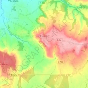
Clicca sulla mappa per visualizzare l'altitudine.
A proposito di questa mappa
Nome: Mappa topografica Exmes, altitudine, rilievo.
Altitudine media: 196 m
Altitudine minima: 123 m
Altitudine massima: 268 m
Altre mappe topografiche
Clicca su una mappa per visualizzarne la topografia, l'altitudine e il rilievo.
Le Bourg-Saint-Léonard
France > Normandie > Orne > Gouffern en Auge
Le Bourg-Saint-Léonard, Gouffern en Auge, Argentan, Orne, Normandie, France métropolitaine, 61310, France
Altitudine media: 168 m
Chambois
France > Normandie > Orne > Gouffern en Auge
Chambois, Gouffern en Auge, Argentan, Orne, Normandie, France métropolitaine, 61160, France
Altitudine media: 115 m
Urou-et-Crennes
France > Normandie > Orne > Gouffern en Auge
Urou-et-Crennes, Gouffern en Auge, Argentan, Orne, Normandie, France métropolitaine, 61200, France
Altitudine media: 184 m
Aubry-en-Exmes
France > Normandie > Orne > Gouffern en Auge
Aubry-en-Exmes, Gouffern en Auge, Argentan, Orne, Normandie, France métropolitaine, 61160, France
Altitudine media: 130 m
Fel
France > Normandie > Orne > Gouffern en Auge
Fel, Gouffern en Auge, Argentan, Orne, Normandie, France métropolitaine, 61160, France
Altitudine media: 123 m
Silly-en-Gouffern
France > Normandie > Orne > Gouffern en Auge
Silly-en-Gouffern, Gouffern en Auge, Argentan, Orne, Normandie, France métropolitaine, 61310, France
Altitudine media: 176 m