
Mappa topografica Dayton
Mappa interattiva
Clicca sulla mappa per visualizzare l'altitudine.
A proposito di questa mappa
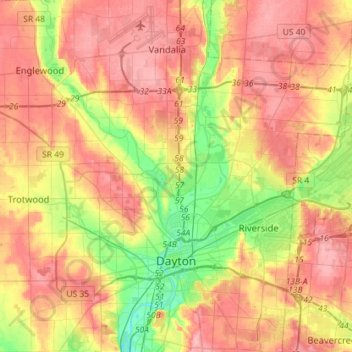
Nome: Mappa topografica Dayton, altitudine, rilievo.
Luogo: Dayton, Montgomery County, Ohio, United States (39.70185 -84.31138 39.92082 -84.09294)
Altitudine media: 270 m
Altitudine minima: 212 m
Altitudine massima: 317 m
Dayton's climate features warm, muggy summers and cold, dry winters, and is classified as a humid continental climate (Köppen Dfa). Unless otherwise noted, all normal figures quoted within the text below are from the official climatology station, Dayton International Airport, at an elevation of 1,000 ft (304.8 m) about 10 mi (16 km) to the north of downtown Dayton, which lies within the valley of the Miami River; thus temperatures there are typically cooler than in downtown.
Altre mappe topografiche
Clicca su una mappa per visualizzarne la topografia, l'altitudine e il rilievo.
Boone Island (historical)
United States > Ohio > Montgomery County > West Carrollton
Boone Island (historical), West Carrollton, Montgomery County, Ohio, 45449, United States
Altitudine media: 276 m
Shiloh
United States > Ohio > Montgomery County > Shiloh
Shiloh, Montgomery County, Ohio, United States
Altitudine media: 262 m
Clement
United States > Ohio > Montgomery County > Riverside
Clement, Riverside, Montgomery County, Ohio, 45432, United States
Altitudine media: 275 m
Kettering
United States > Ohio > Montgomery County
Kettering, Montgomery County, Ohio, United States
Altitudine media: 275 m
Miamisburg Community Park
United States > Ohio > Montgomery County > Miamisburg
Miamisburg Community Park, Miamisburg, Miami Township, Montgomery County, Ohio, United States
Altitudine media: 241 m
Berkley Heights
United States > Ohio > Montgomery County > Kettering
Berkley Heights, Kettering, Montgomery County, Ohio, 45439, United States
Altitudine media: 253 m
Clayton
United States > Ohio > Montgomery County
Clayton, Montgomery County, Ohio, 45315, United States
Altitudine media: 300 m
Dayton
United States > Ohio > Montgomery County > Dayton
Dayton, Montgomery County, Ohio, 45423, United States
Altitudine media: 270 m
Miamisburg
United States > Ohio > Montgomery County
Miamisburg, Montgomery County, Ohio, 45342, United States
Altitudine media: 247 m
Patterson
United States > Ohio > Montgomery County > Dayton
Patterson, Dayton, Montgomery County, Ohio, 45408, United States
Altitudine media: 233 m
Farmersville
United States > Ohio > Montgomery County
Farmersville, Montgomery County, Ohio, 45325, United States
Altitudine media: 259 m
West Carrollton
United States > Ohio > Montgomery County
West Carrollton, Montgomery County, Ohio, 45449, United States
Altitudine media: 238 m
Washington Township
United States > Ohio > Montgomery County
Washington Township, Montgomery County, Ohio, United States
Altitudine media: 285 m
Residence Park
United States > Ohio > Montgomery County > Dayton
Residence Park, Dayton, Montgomery County, Ohio, 45428, United States
Altitudine media: 266 m
Oakwood
United States > Ohio > Montgomery County
Oakwood, Montgomery County, Ohio, 45419, United States
Altitudine media: 280 m
West Side
United States > Ohio > Montgomery County > Dayton
West Side, Dayton, Montgomery County, Ohio, 45407, United States
Altitudine media: 232 m
Riverside
United States > Ohio > Montgomery County
Riverside, Montgomery County, Ohio, 45437, United States
Altitudine media: 256 m
Trotwood
United States > Ohio > Montgomery County
Trotwood, Montgomery County, Ohio, United States
Altitudine media: 275 m
Englewood
United States > Ohio > Montgomery County
Englewood, Montgomery County, Ohio, 45322, United States
Altitudine media: 282 m
Greenmont
United States > Ohio > Montgomery County > Kettering
Greenmont, Kettering, Montgomery County, Ohio, 45420, United States
Altitudine media: 282 m
Pasadena
United States > Ohio > Montgomery County > Kettering
Pasadena, Kettering, Montgomery County, Ohio, 45429, United States
Altitudine media: 299 m
Miami Township
United States > Ohio > Montgomery County
Miami Township, Montgomery County, Ohio, United States
Altitudine media: 272 m
Centerville
United States > Ohio > Montgomery County > Centerville > Centerville
Centerville, Montgomery County, Ohio, 45459, United States
Altitudine media: 288 m
Miami Shores
United States > Ohio > Montgomery County > Moraine
Miami Shores, Moraine, Montgomery County, Ohio, 45439, United States
Altitudine media: 232 m
Miamisburg
United States > Ohio > Montgomery County > Miamisburg > Miamisburg
Miamisburg, Montgomery County, Ohio, 45342, United States
Altitudine media: 245 m
Crown Point
United States > Ohio > Montgomery County > Dayton > Crown Point
Crown Point, Dayton, Montgomery County, Ohio, 45428, United States
Altitudine media: 273 m
New Lebanon
United States > Ohio > Montgomery County > New Lebanon
New Lebanon, Montgomery County, Ohio, United States
Altitudine media: 278 m
Oakdale
United States > Ohio > Montgomery County > Kettering
Oakdale, Kettering, Montgomery County, Ohio, 45429, United States
Altitudine media: 297 m
Centerville
United States > Ohio > Montgomery County
Centerville, Montgomery County, Ohio, United States
Altitudine media: 287 m
Germantown
United States > Ohio > Montgomery County
Germantown, Montgomery County, Ohio, 45327, United States
Altitudine media: 238 m
Vandalia
United States > Ohio > Montgomery County
Vandalia, Montgomery County, Ohio, 45377, United States
Altitudine media: 280 m
Huber Heights
United States > Ohio > Montgomery County
Huber Heights, Montgomery County, Ohio, 45424, United States
Altitudine media: 274 m