
Mappa topografica Bengaluru
Mappa interattiva
Clicca sulla mappa per visualizzare l'altitudine.
A proposito di questa mappa
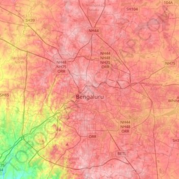
Nome: Mappa topografica Bengaluru, altitudine, rilievo.
Altitudine media: 881 m
Altitudine minima: 722 m
Altitudine massima: 965 m
Bangalore (/bæŋɡəˈlɔːr/), officially Bengaluru (Kannada pronunciation: [ˈbeŋgɐɭuːɾu] (listen)), is the capital and largest city of the Indian state of Karnataka. It has a population of more than 8 million and a metropolitan population of around 11 million, making it the third most populous city and fifth most populous urban agglomeration in India, as well as the largest city in South India, and the 27th largest city in the world. Located on the Deccan Plateau, at a height of over 900 m (3,000 ft) above sea level, Bangalore has a pleasant climate throughout the year, with its parks and green spaces earning it the reputation as the "Garden City" of India. Its elevation is the highest among the major cities of India. An aerospace and electronics hub since the 1960s, Bangalore is widely regarded as the "Silicon Valley of India" because of its role as the nation's leading information technology (IT) exporter. In the Ease of Living Index 2020 (published by the Ministry of Housing and Urban Affairs), it was ranked the most livable Indian city with a population of over a million. It also ranks among the highest Indian cities in terms of global livability rankings as well.
Altre mappe topografiche
Clicca su una mappa per visualizzarne la topografia, l'altitudine e il rilievo.
Bengaluru
India > Karnataka > Bangalore North
Bengaluru, Bangalore North, Bengaluru Urban, Karnataka, 560001, India
Altitudine media: 879 m
Byatarayanapura
India > Karnataka > Bangalore North > Bengaluru
Byatarayanapura, Yelahanka Zone, Bengaluru, Bangalore North, Bengaluru Urban District, Karnataka, India, Nagavara lake
Altitudine media: 896 m
Jagajivanaramnagar
India > Karnataka > Bangalore North > Bengaluru
Jagajivanaramnagar, West Zone, Bengaluru, Bangalore North, Bengaluru Urban District, Karnataka, India
Altitudine media: 874 m
Kammasandra
India > Karnataka > Bangalore North
Kammasandra, Bangalore North, Bengaluru Urban District, Karnataka, 562162, India
Altitudine media: 848 m
Cubbon Park
India > Karnataka > Bangalore North > Bengaluru
Cubbon Park, Sampangiram Nagar Ward, East Zone, Bengaluru, Bangalore North, Bangalore Urban, Karnataka, India
Altitudine media: 917 m
Bagalakunte
India > Karnataka > Bangalore North > Bengaluru
Bagalakunte, Dasarahalli Zone, Bengaluru, Bangalore North, Bangalore Urban, Karnataka, India
Altitudine media: 888 m
Basava Dhama Park
India > Karnataka > Bangalore North > Bengaluru
Basava Dhama Park, Rajajinagara 1st R Block, Nagapura Ward, West Zone, Bengaluru, Bangalore North, Bangalore Urban, Karnataka, India
Altitudine media: 920 m
Ulsoor Lake
India > Karnataka > Bangalore North > Bengaluru
Ulsoor Lake, Halasooru, East Zone, Bengaluru, Bangalore North, Bangalore Urban, Karnataka, India
Altitudine media: 905 m
HBR Layout
India > Karnataka > Bangalore North > Bengaluru
HBR Layout, East Zone, Bengaluru, Bangalore North, Bangalore Urban, Karnataka, 560045, India
Altitudine media: 893 m
Kammanahalli
India > Karnataka > Bangalore North > Bengaluru
Kammanahalli, East Zone, Bengaluru, Bangalore North, Bangalore Urban, Karnataka, 560033, India
Altitudine media: 908 m
Madhavara
India > Karnataka > Bangalore North
Madhavara, Bangalore North, Bangalore Urban, Karnataka, 562162, India
Altitudine media: 863 m
Herohalli Lake
India > Karnataka > Bangalore North > Bengaluru
Herohalli Lake, Chowdeswari Ward, Yelahanka Zone, Bengaluru, Bangalore North, Bangalore Urban, Karnataka, India
Altitudine media: 911 m
HRBR Layout
India > Karnataka > Bangalore North > Bengaluru
HRBR Layout, Kacharkanahalli, East Zone, Bengaluru, Bangalore North, Bangalore Urban, Karnataka, 540045, India
Altitudine media: 895 m
Craig Park Layout
India > Karnataka > Bangalore North > Bengaluru
Craig Park Layout, Shantala Nagar, East Zone, Bengaluru, Bangalore North, Bangalore Urban, Karnataka, India
Altitudine media: 909 m
Hanumanth Nagar Ward
India > Karnataka > Bangalore North > Bengaluru
Hanumanth Nagar Ward, South Zone, Bengaluru, Bangalore North, Bangalore Urban, Karnataka, India
Altitudine media: 894 m
Hesaraghatta Lake
India > Karnataka > Bangalore North > Aivarakandapura
Hesaraghatta Lake, Aivarakandapura, Bangalore North, Bangalore Urban, Karnataka, India
Altitudine media: 868 m
Singanayakanahalli
India > Karnataka > Bangalore North > Singanayakanahalli
Singanayakanahalli, Bangalore North, Bangalore Urban, Karnataka, 562157, India
Altitudine media: 917 m
Kudhurgere Colony
India > Karnataka > Bangalore North > Kudhurgere Colony
Kudhurgere Colony, Bangalore North, Bangalore Urban, Karnataka, 562162, India
Altitudine media: 864 m
Kadabageri
India > Karnataka > Bangalore North > Kadabageri
Kadabageri, Bangalore North, Bangalore Urban, Karnataka, India
Altitudine media: 846 m
Tarabanahalli
India > Karnataka > Bangalore North > Tarabanahalli
Tarabanahalli, Bangalore North, Bangalore Urban, Karnataka, IAM IN BANG, India
Altitudine media: 915 m
Hesaraghatta
India > Karnataka > Bangalore North > Hesaraghatta
Hesaraghatta, Bangalore North, Bangalore Urban, Karnataka, 560088, India
Altitudine media: 865 m