
Mappa topografica Bury St Edmunds
Mappa interattiva
Clicca sulla mappa per visualizzare l'altitudine.
A proposito di questa mappa
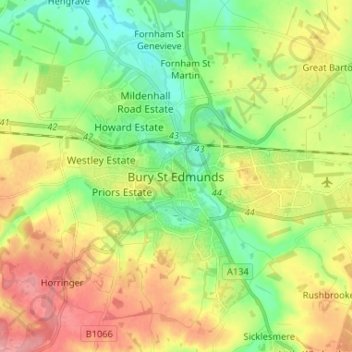
Nome: Mappa topografica Bury St Edmunds, altitudine, rilievo.
Altitudine media: 59 m
Altitudine minima: 21 m
Altitudine massima: 107 m
The name Bury is etymologically connected with borough, which has cognates in other Germanic languages such as the German burg meaning "fortress, castle"; Old Norse borg meaning "wall, castle"; and Gothic baurgs meaning "city". They all derive from Proto-Germanic *burgs meaning "fortress". This in turn derives from the Proto-Indo-European root *bhrgh meaning "fortified elevation", with cognates including Welsh bera ("stack") and Sanskrit bhrant- ("high, elevated building").