
Mappa topografica Dehradun
Mappa interattiva
Clicca sulla mappa per visualizzare l'altitudine.
A proposito di questa mappa
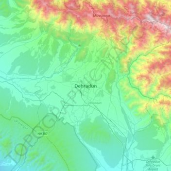
Nome: Mappa topografica Dehradun, altitudine, rilievo.
Luogo: Dehradun, Dehradun District, Uttarakhand, 248001, India (30.16556 77.88368 30.48556 78.20368)
Altitudine media: 904 m
Altitudine minima: 402 m
Altitudine massima: 2.568 m
The city of Dehradun mainly lies in Doon Valley and is at a varying height from 410 m (1,350 ft) in Clement Town to above 700 m (2,300 ft) at Malsi which is 15 km (9.3 mi) from the city. However, the average elevation is 450 m (1,480 ft) above sea level. Malsi is the starting point of Lesser Himalayan Range that extends to Mussoorie and beyond. Jaunsar-Bawar hills in Dehradun district rises to 3,700 m (12,100 ft) above sea level. The hilly region of Mussoorie goes up to a height of 1,870–2,017 m (6,135–6,617 ft) above sea level. Its geomorphological and meteorological characteristics make it prone to a number of natural hazards. Beside earthquakes, the region is frequently devastated by landslides, cloudbursts, flash-floods, cold waves and hailstorms.
Altre mappe topografiche
Clicca su una mappa per visualizzarne la topografia, l'altitudine e il rilievo.
Mussoorie
India > Uttarakhand > Dehradun
Mussoorie, Dehradun, Uttarakhand, 248179, India
Altitudine media: 1.594 m
dwara
India > Uttarakhand > Dehradun > Dehradun
dwara, Dehradun, Uttarakhand, 248001, India
Altitudine media: 868 m
Chandrabani
India > Uttarakhand > Dehradun > Dehradun
Chandrabani, Dehradun, Uttarakhand, 248001, India
Altitudine media: 607 m
Rispana River
India > Uttarakhand > Dehradun > Dehradun
Rispana River, Dehradun, Uttarakhand, 248001, India
Altitudine media: 624 m
dhanaula
India > Uttarakhand > Dehradun > dhanaula
dhanaula, Dehradun, Uttarakhand, 248009, India
Altitudine media: 1.011 m