
Mappa topografica Niphad
Mappa interattiva
Clicca sulla mappa per visualizzare l'altitudine.
A proposito di questa mappa
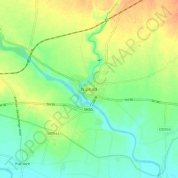
Nome: Mappa topografica Niphad, altitudine, rilievo.
Luogo: Niphad, Nashik District, Maharashtra, 422230, India (20.03969 74.06711 20.11969 74.14711)
Altitudine media: 550 m
Altitudine minima: 534 m
Altitudine massima: 570 m
Niphad is the name both of the town and the Taluka headquartered there. It is within the Nashik District of Maharashtra, India. The Marathi name signifies "a place without mountains", and indeed the taluka's topography is fairly level, with hardly any hills. It is served by Niphad railway station. Niphad's latitude and longitude coordinates are 20°5′0″N 74°7′0″E / 20.08333°N 74.11667°E / 20.08333; 74.11667. Located northeast of Nashik city, the Taluka borders Sinnar, Nashik, Dindori, Chandwad, and Yeola Talukas and Ahmednagar District, and has no direct access to the sea. The Niphad Sub-Division is composed of Niphad, Sinnar and Yeola Talukas.
Altre mappe topografiche
Clicca su una mappa per visualizzarne la topografia, l'altitudine e il rilievo.
Lasalgaon
India > Maharashtra > Niphad
Lasalgaon, Niphad, Nashik District, Maharashtra, 422306, India
Altitudine media: 586 m