
Mappa topografica Aberdeen
Mappa interattiva
Clicca sulla mappa per visualizzare l'altitudine.
A proposito di questa mappa
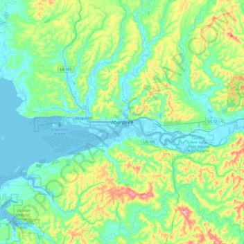
Nome: Mappa topografica Aberdeen, altitudine, rilievo.
Altitudine media: 66 m
Altitudine minima: -5 m
Altitudine massima: 286 m
Aberdeen is at the eastern end of Grays Harbor, near the mouth of the Chehalis River and southwest of the Olympic Mountains. Grays Harbor is notable as the northernmost ria on North America's Pacific Coast because it has remained free of glaciers throughout the Quaternary due to unfavorable topography and warm temperatures. It is thought that, during glacial periods of the Quaternary, the Chehalis River was a major refugium for aquatic species, as was the west coast from the Olympic Peninsula southward for plants that later formed the northern part of the Pacific temperate rainforest in formerly glaciated areas.
Altre mappe topografiche
Clicca su una mappa per visualizzarne la topografia, l'altitudine e il rilievo.
North Aberdeen
United States > Washington > Grays Harbor County > Aberdeen > North Aberdeen
North Aberdeen, Aberdeen, Grays Harbor County, Washington, 98537-0525, United States
Altitudine media: 37 m