
Mappa topografica Village of Mamaroneck
Mappa interattiva
Clicca sulla mappa per visualizzare l'altitudine.
A proposito di questa mappa
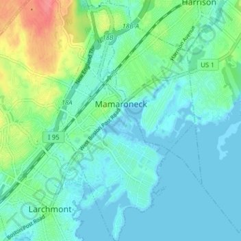
Nome: Mappa topografica Village of Mamaroneck, altitudine, rilievo.
Altitudine media: 15 m
Altitudine minima: -3 m
Altitudine massima: 65 m
Other areas of the town include Heathcote Hill, overlooking the harbor, Harbor Heights (the heights) to the northeast, Old Rye Neck (settled in the 1880s), Rye Neck (settled in the 1920s and 1930s), Orienta, and Washingtonville, better known as "The Flats", due to the flat, low-lying topography of the area.
Altre mappe topografiche
Clicca su una mappa per visualizzarne la topografia, l'altitudine e il rilievo.
Village of Larchmont
United States > New York > Westchester County > Town of Mamaroneck
Village of Larchmont, Town of Mamaroneck, Westchester County, New York, 10538, United States
Altitudine media: 8 m