
Mappa topografica Aberdeen
Mappa interattiva
Clicca sulla mappa per visualizzare l'altitudine.
A proposito di questa mappa
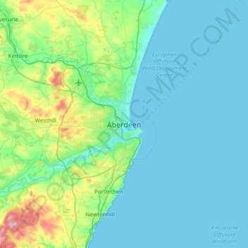
Nome: Mappa topografica Aberdeen, altitudine, rilievo.
Luogo: Aberdeen, Aberdeen City, Scotland, AB11 5EQ, United Kingdom (56.98824 -2.25281 57.30824 -1.93281)
Altitudine media: 52 m
Altitudine minima: 0 m
Altitudine massima: 368 m
Two weather stations collect climate data for the area, Aberdeen/Dyce Airport, and Craibstone. Both are about 4 1⁄2 miles (7 km) to the north west of the city centre, and given that they are in close proximity to each other, exhibit very similar climatic regimes. Dyce tends to have marginally warmer daytime temperatures year round owing to its slightly lower elevation, though it is more susceptible to harsh frosts. The coldest temperature to occur in recent years was −16.8 °C (1.8 °F) during December 2010, while the following winter, Dyce set a new February high temperature station record on 28 February 2012 of 17.2 °C (63.0 °F)., and a new March high temperature record of 21.6 °C (70.9 °F) on 25 March 2012.
Altre mappe topografiche
Clicca su una mappa per visualizzarne la topografia, l'altitudine e il rilievo.
Westburn Park
United Kingdom > Scotland > Aberdeen
Westburn Park, Hilton, Rosemount, Aberdeen, Scotland, AB25 3DE, United Kingdom
Altitudine media: 53 m
Dyce
United Kingdom > Scotland > Aberdeen > Dyce
Dyce, Aberdeen, Scotland, AB21 7AU, United Kingdom
Altitudine media: 91 m
Bon Accord Terrace Gardens
United Kingdom > Scotland > Aberdeen
Bon Accord Terrace Gardens, Froghall, Ferryhill, Aberdeen, Aberdeen City, Scotland, United Kingdom
Altitudine media: 25 m
Castlehill and Pittodrie
United Kingdom > Scotland > Aberdeen
Castlehill and Pittodrie, Aberdeen, Aberdeen City, Scotland, United Kingdom
Altitudine media: 11 m
Leuchar Burn
United Kingdom > Scotland > Aberdeen
Leuchar Burn, Aberdeen, Aberdeen City, Scotland, AB14 0NJ, United Kingdom
Altitudine media: 85 m